ALL PHOTOS CLICK FULL SCREEN.
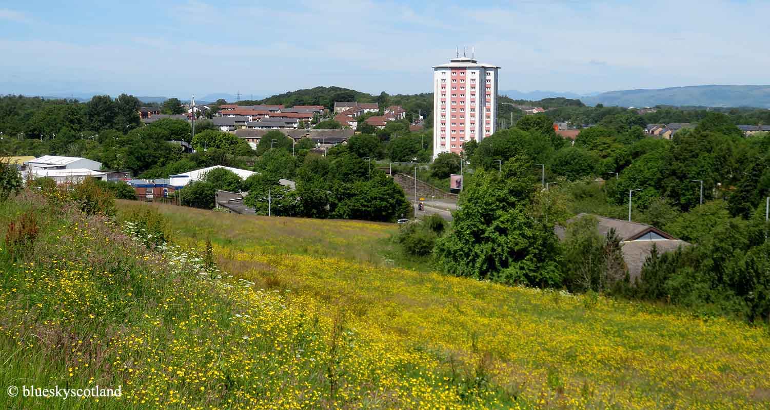
South Nitshill from the bottom of the Grassy Hill. I've used this photo before a few years ago as I was driving past in the car heading for Rouken Glen Park to go a walk there and instead this view of wild flowers and a long carpet of buttercups covering every inch of this banana shaped hill blew me away instead. Again it was June when this occurred.
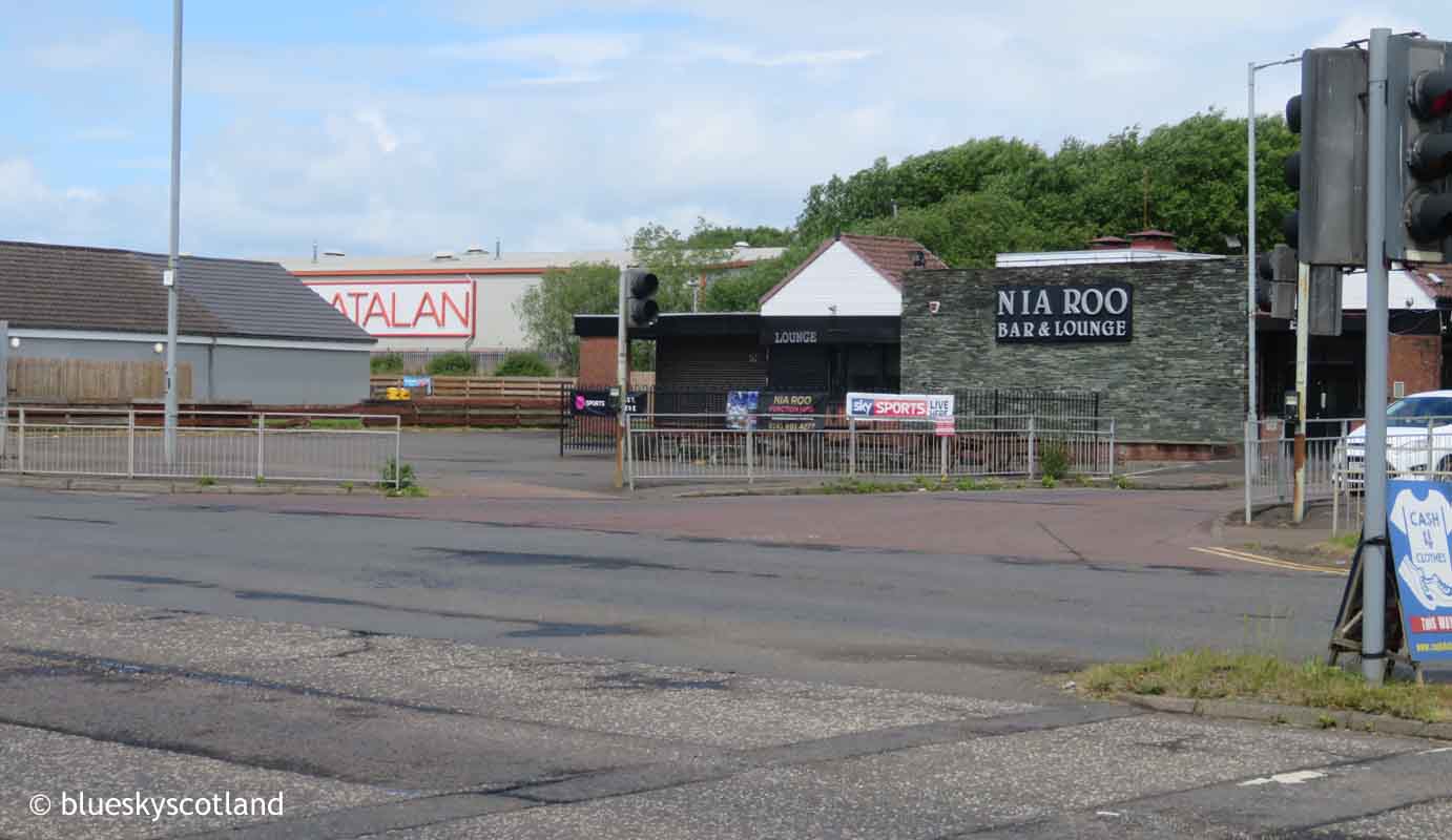
So I parked in the small trading estate beside the Nia Roo pub and went for a wander here instead. I enjoyed it so much I wandered up the nearby Corselet minor road into the Dams to Darnley Country Park as far as the stone bridge halfway up. There I discovered a brand new path ( to me anyway) and followed it far enough to realise that it was heading in the direction of Barrhead. As I'd arranged to meet my friend Anne later on, somewhere else, I cut it short but intended to come back someday to explore the full route.
This is South Nitshill, The Valley. Still the same low level houses that I remember as a child growing up. This is where you come out after the first part of the walk described in the part one blog post. From here you walk rightwards to the roundabout.
And this is the roundabout you come out at. Still in South Nitshill looking at Parkhouse Road. Mostly well kept owner occupied houses. It used to look like this in the 1990s, just before the tenement estate here was knocked down. Photo below.
It's now a very different estate, just like the neighbouring Darnley and Priesthill, all also low level new housing stock, many owner occupied. Growing up in the 1960s the fields, farms and dairy cattle started on the other side of Parkhouse Road. An area larger than Pollok Country Park has been lost since then to the newish housing estates of Parkhouse, Southpark, and Deaconsbank. Three times that size if you include the Darnley ( built 1970s) and the new houses going up in Barrhead and Neilston at the present time. So that's a huge chunk of farmland no longer there. Farms and farmers therefore are the guardians of the countryside as once they move, die, or are abandoned housing developments tend to move into the vacated land within a few years.

Having said that there's still so much to admire in this area and great walking potential. This is Parkhouse Road/Darnley Road looking towards Barrhead. Anyone missing out the fields section mentioned in the last post and using this pavement from Cowan Park instead will come out here as will those crossing the fields on grass paths as described via the last post. Just across the road from here the path continues skirting behind Parkhouse Estate seen three photos ago.
This is another view of the same roundabout as it shows exactly where the path is. Where the large pylon is on the far side of Parkhouse Road.
You are now on the edge of Dams to Darnley Country Park. And the path you will need to follow to do this walk. Entire walk around 3 hours but you can easily extend this by including the Barrhead Dams or walking to Kennishead via a scenic green path/cycle-track between Darnley and Arden which also leads to Silverburn Shopping Centre, via a path beside the Brock Burn, as described in a previous blog post.
Although the Parkhouse Estate is only a short distance away, on the left here, you are hardly aware of it at all and it feels like a wild walk.
Pastel perfection. A wild dog rose. Easily my favourite scent of any flower, including garden roses.
What used to be fields grazed short by cattle... or crops like barley or turnips and bordered by neat hedgerows full of nesting birds and small mammals is now almost wild open heath- land with this central path running along a low ridge-line.
Looking towards Barrhead from it you get more of an idea of what it used to look like in the 1960s with a distant field system layout still in place.The whole of Pollok including South Nitshill, Darnley, and Priesthill used to be farms and rolling farmland similar to this with many of the district names taken from long gone farms.

And a few fields away you can see Barrhead and St John's catholic church spire sticking up. One of the reasons I like that building is the views of it from afar. This view reminds me of early Rupert the Bear annuals. I only ever had three, sent by an Aunt. I preferred Oor Wullie and The Broons. (working class families, like mine, but always black and white strips.) Rupert the Bear was in vivid colour and featured illustrations very like this with the mad professor landing his tiny airplane in a village castle tower. Or scenic cliff tops, smugglers coves, and beaches. Or hills... like the Brownside Braes, above, (or more likely, The Chilterns.) I liked the colour and places featured but didn't like the rhyming couplets with everything, some of the more exotic characters, or the fact they seemed to be detached from the world I knew around me. At that age I didn't realise it was a middle class/ upper class bubble I was gazing into I just knew there was something off about it. A very guilty pleasure to be kept hidden. Like saying to your same aged friends you liked The Osmonds, The Carpenters, or Abba back then. Not cool at all. A talking teddy bear! A sure way to get beaten up. I liked the illustrations though and they definitely made an impact on my psyche.

Another view from this splendid path. Cowan Park. It's playground rides, Dairy cattle. Field system layout for Dubbs Farm... which may be generations old. Unchanged for 70 years at least... Maybe centuries old in the farm's case.
I grew up wandering with herds of cattle as a child and teenager so nice to see them still here. And fields of horses on the nearby Salterland Road.

Another view from this path. Without livestock to graze it down the vegetation soon becomes a tangled waist high jungle with small trees appearing on the way to becoming mature deciduous woodland eventually. The natural progress of wild land in the UK, left to itself. Do not know if this is better for nature than the field system layout in the distance but I suspect not. Did not see many birds, butterflies or insects here and a solo Chris Packham programme compared three suburban gardens. A carefully maintained one , a mixed one of short lawn but with wild patches, and a tangled overgrown one. The middle one was best. When you think about it birds have to find food easily when nesting. Very hard in this tangle. I did see loads of butterflies this month on a proper heath-land area not far from here a week later. So the contrast was stark. Although a beautiful walk car parking is hard here so I would always recommend coming by bus or train with the advantage that you can do linear walks from Barrhead to Nitshill, Darnley or Kennishead.

Another advantage is that it's quiet here. One local dog walker was all I met midweek on a cracking summer day. I've never known it busy at any time in the Dams to Darnley Country Park, Unlike the very popular Mugdock area above Bearsden and Milngavie. This path leads down to the Stone bridge then Darnley Mill and The Darnley Tree. From there you walk along Nitshill Road to the train station at Nitshill.. or I did anyway.
Another view of the route taken.
The railway bridge at Nitshill.
One thing that was new here was an access ramp leading to both platforms replacing the old bridge that used to cross the tracks.
Replacing this bridge. Now gone.
Nitshill from the train station.
Info on the mining disaster in the mid 1800s when 61 miners lost their life down the Victoria Pit. As an ex coal mining village and industrial hub pre 1960s with brick works, lime works and several quarries in the area there used to be about six or seven pubs in Nitshill village growing up. Now there's one remaining plus the Nia Roo on Nitshill Road 10 minutes walk away.
Still there.
And a nice war memorial cross at the station.
A few empty plots of land remain in Nitshill village however. This one used to have a car showroom/garage and other buildings facing onto the street.

Normally I like waste ground as it's never wasted for me but this project if it's planned for here should plug this gap nicely. I can think of worst places to live. Although still a working class area I'd imagine many of the ex council houses in nearby Dove Street or Cleeves Road are owned now, they look well kept, good bus and train connections to the city centre; plenty of shops 5 mins away. Silverburn close by. Great walks everywhere in this district. Always has been. I went several walks in Clarkston, Williamwood, Cathcart and Newton Mearns with Anne several years ago, all middle class districts of expensive suburbia, and never posted any of them. Perfectly pleasant detached or semi detached roads of houses but boring to walk around and not changed one bit in 70 years. This place still has character. I was not bored here growing up. And houses are probably cheaper than in so called 'desirable' areas.

A view from the train station of South Nitshill in June 2024. Although a modest mound, under 200 feet in height, views are great up here in all directions. Winter or summer, night or day. The south side, i.e. here, is also the greenest, most rural part, in all of Glasgow. Woods, streams, dams, cattle, horses, fields... it's got the lot. Low hill ranges only walking distance away.
It could be the nearest you will get to an earthly heaven. It certainly was for me.
The train back from Nitshill. Under 30 mins to Glasgow Central.
The line of new Glasgow hotels built along the River Clyde waterfront seen from the train. The end.