ALL PHOTOS CLICK FULL SCREEN
Our first club trip of winter was an autumn visit to the English Lake District. The weather forecast midweek was poor but the great thing about the lakes is that they are very different from Scotland. Hundreds of scenic paths crisscross the region, dozens in every valley....many are sheltered with tree cover... wet weather alternatives exist in the form of pretty towns and villages to explore... free to visit underground caves, quarries and tunnels are a possibility... and despite the region's comparative overall size many more small rugged peaks exist here below the mist level within easy driving distance. This is Walla Crag, 376 metres, just above Keswick, and it soon became my small hill of choice when rain and gales awaited us on our arrival. Everything above this height was frequently obscured in mist and rain but I had a cunning plan.
It had been many years since I'd explored Keswick properly and I had fond memories of it. I first travelled down here in the early 1970s on a bus trip from Barrhead as an eager teenager and it opened up many possibilities. I met someone on the bus who was open to reasonable suggestion and we climbed Walla Crag together. She came from Bellshill, an outlying town east of Glasgow, which until I met her, I had no idea existed. It sounded exotic and my path in life was fixed. My first butterfly.
With a strong nostalgic element to the walk therefore Alex kindly dropped me off at the Pencil Factory/museum in Keswick, seen above, before meeting up with other club members to climb Binsey, 447 metres, just north of Bassenthwaite Lake. This would take me away from trees, shelter and Keswick itself so I declined their offer to join them. Suggestion only works if you desire to do what's suggested in the first place.
When they departed I had a lovely walk through the always busy town centre, lined with outdoor shops, pubs and restaurants, all competing for trade, then entered Keswick suburbia through the back streets. This ornate picture house was opened in 1913 and the Lake District has attracted tourists here since the early 1800s, William Wordsworth, and the dawning of the Romantic Age. Money has always poured into the Lakes since then and the tourist industry here generates sizable income year round. Contrast that with a very short, often wet, summer season in the Highlands of Scotland and you soon realize why there is not the same infrastructure available during wet weather, with very little to do in a land long stripped of its natural forests, its indigenous people, then remodeled by royal inclination as a Victorian theme park for the hunting, fishing and shooting brigade. Many of the Scottish "traditions" so loved by tourists today were actually dreamed up by a German prince, a Queen and a Sir, promoting his popular novels of times gone by to sell Scotland as a playground for the rich after the clearances had left them empty and open for plunder. In short, the establishment had a full makeover to suit their own tastes, ideas and expectations of the place, as they always do.
West Coast Scotland still has a beautiful if bleak landscape in fine weather, but in heavy rain, drizzle or storm it can be one of the most miserable and unforgiving regions on earth, with little natural shelter, free to visit infrastructure or free entertainment available on offer.
Yes readers, I like the Lake District, especially in bad weather. So let's keep it pretty for the poor windswept Scots on vacation to shelter in :o)
Picture postcard suburban Keswick. Plenty of shelter, sunshine and lush scenery despite a rain lashed Cat Bells in the distance. (well, it's over in that direction anyway)
An amazing house with great architectural detail.
Climbing up the back streets through wonderful suburbia. On a day of frequent stormy squalls up high this is low level tropical heaven for me. I'm definitely a creature of honey and sunlight. A honey badger.
For anyone interested in this 3 to 4 hour walk through a smorgasbord of varied scenic delights the route follows the curving yellow road rising out of Keswick on the Landranger OS map 90. Penrith and Keswick. Ambleside. It then reaches the MS164, turns off onto the A591, on a pavement, then follows pleasant signposted lanes past Castlerigg and Rakefoot to the summit of Walla Crag. A five star outing. Highly recommended lower level alternative to save a poor day up high.
Keswick from the A591 above the town. A sea of sheltering trees. You can see the minor road I travelled up in this photo with a car on it. (there is a car park directly under Walla Crag but you miss the best bit of the walk that way.)
A view of Derwent Water and Keswick in autumn colours.
As planned I didn't get rained on at all though the higher surrounding peaks were frequently lashed by heavy showers and invisible most of the day.
It was a great place for rainbows with several double ones observed and few other walkers due to the forecast.
Derwent Isle and Friar's Crag area from Walla Crag.
Rain squall hitting the Derwent Fells... me in bright sunshine... just the way I like it. Why settle for anything less when I enjoy it so much? 7 years without a raindrop.
Another double rainbow over Keswick and Skiddaw/Blencathra district.
On the return you can either retrace your steps then take the path down Brockle Beck into Keswick or detour via the Great Wood under the Crag to reach the Stable Hills area. This allows you to return via the Derwent Water shoreline, seen above, which is very pleasant, even on a grey day. I opted for a steep, brutal descent off the far end of the crag but I wouldn't recommend it unless you like severe inclines and fence hugging, which is what I did most of the way down. A Lake District fence Via Ferrata but I was glad it was there
A purpose built path beside the road later on means you are still in grand scenery, always a feature in the Lakes, thanks to it's Victorian tourist legacy. There are probably more scenic walking paths in the Lake District than in the whole of West Coast Scotland. Another reason why I like it here. You never run out of new areas to explore. A lifetime's worth squeezed into a relatively small compact area.
Yes sir. I love the Lake District with a passion worthy of W.W, Dorothy, De Quincy and Coleridge. A great first day.
Talking of enjoyable nostalgia here's one of the best programmes of the last year, available on you tube. Each hour long episode covers a decade of change in Britain seen through the eyes of a likable family. Learned a lot with every episode, fun to watch, and just excellent in every way. Might as well start with the 1950s. Even if you just watch this for 10 minutes it explains what it's all about. A joy of remembering or an education for younger viewers who didn't live through it. P.S. The mum is not the best cook to wear an apron :o) Also available... the 1960s,1970s, 1980s, 1990s.
ALL PHOTOS CLICK FULL SCREEN.
As autumn is in full swing at the moment across the UK I thought I'd do an autumnal collection to celebrate my 400th post on this blog. It's always better if you can get autumn colours damp for a photograph as they stand out more. October is perfect for this as cold mornings at this time of year often produce mist inversions over the city. Glasgow sits in a flat bowl surrounded by hill ranges so it tends to attract this phenomenon, as do other parts of the world with a similar geological set up and the right mix of temperatures colliding. Add in a few dozen drumlins which sometimes stick out the mist blanket, or tower blocks on slopes poking above into bright sunshine, and you have a perfect combination for natural magic happening.
Power lines descending into the city below from the higher surrounding hills to the north. I stopped off at a local supermarket to buy a quick breakfast, some tasty treats for a friend afterwards, and bumped into someone with a very expensive camera around his neck bemoaning the fact that "there was nothing worth photographing in this murk all weekend and that he might as well go home and take the kids to the pictures."
As I'm all for father's spending quality time with their children on Sunday's I didn't make the competition any the wiser. Besides, I don't want my favourite locations getting too popular. Luckily, my blog is mainly visited by Americans and Russians these days, judging by the stats info, so any obscure tiny lay-bys I favour remain empty.
According to the weather forecast the thick mist would burn off by lunchtime over the city so I hung around the high land just above the mist level before dropping down slowly as it lifted. Cattle grazing in fields above Milngavie.
A silver kingdom awaited with spider webs illuminated by the rising sun plainly visible like never before, covered in early morning dew.
Autumn seen through a spider web wonderland of hanging droplets. Each a tiny looking glass.
Spider craft at work.
A misty view over Bearsden. Towers and Ravens.
A grey Squizzell. Companion to the Jabberwocky. Well...It was a Lewis Carroll and Alice sort of day.
By lunchtime, as the BBC Met office witches and warlocks had predicted, with their weather science, spells and charts, it was a beautiful day and the autumn colours now sparked like dew dipped diamonds in the sunshine. A perfect time for colour capture. The mist in the valleys had either dissipated or climbed upwards to the higher slopes.
So it was down to the parks for me to get some photos before the leaves dried out. Like wet pebbles collected on a beach they are never as vivid once they dry out, brought back home, then placed on a shelf or even in a water filled jar. True magic is like that sometimes. Setting is everything.
Clydebank with the mist rising over the Kilpatrick Hills.
Autumn glory and time for tea with my Alice. Appropriately, maple syrup and pecan nut pastries in this instance. Three each. With Savage Peculiar indeed.
View over The Wood of Knights.
The Golden Highway into Glasgow.
Mushrooms for tea... or maybe not. Well... I see enough strange creatures wandering this realm in daylight already.
The Hill. Wood of Knights. Glasgow in Autumn.
Kate and Miranda R with some more witch craft from the early 1990s.
ALL PHOTOS CLICK FULL SCREEN.
Got a phone call from Alex last weekend who was keen to make the most of the continuing "Indian Autumn" we are enjoying in Scotland at the moment with stunning sunny days, freezing cold nights and thick morning mists hanging in the valleys. He suggested Broomy Law, 426 metres and also a lower hill above Biggar near Balwaiste Farm at 363 metres. Both hills are in the rolling landscape of the Scottish Borders. For him they were two more hills on his lists to capture and for me it was a good opportunity to indulge my own passion, which is capturing great scenery.
This is Tinto, 707 metres, seen above, one of the great iconic peaks of the region but the only one that is busy and popular hereabouts.
Broomy Law summit. The Upper Clyde Valley. Landranger OS Map 72 has long been a favourite of mine as it holds some of the best cycling routes in the country over a network of minor roads with stunning views round every corner. This area covered by the map is very varied with deep wooded river gorges, open meadows, cattle, horses, sheep farming, arable crops, high rolling peaks and a bare windswept plateau region around Shotts and Forth where the sky spreads open across flat wide vistas from horizon to horizon.
Although only an hour's drive from Glasgow it is far enough east to grow and produce a harvest, which doesn't really happen on the west coast anymore to the same extent with its wet climate and permanently soggy fields.
Thanks to Alex, who is always prepared regarding online homework and handy parking spots for his hills we stopped in the quaintly named Candy Mill and found an unobtrusive spot before walking along the old Roman road and up our hill of choice. One of the things I like about this area is that the hills are wild and beautiful yet rarely frequented, mostly untroubled by paths. Views are wide and open and each hill has room to breathe as a separate distinctive peak, not crowded into a jumble of other surrounding hills.
The mighty Culter Fell, at 748 metres, the high point of a complex rolling landscape that always seems far higher when cycling or walking through it due to flat surrounding lands. We were lucky with our choice as we stayed below the mist level the entire day yet the higher summits of Dollar Law, 817 metres, and Broad Law, 840 metres stayed stubbornly buried under a blanket of thick murk. One benefit of doing smaller hills.
Another benefit of lower levels is remaining in lush scenery which visibly changes from week to week. It should come as no surprise that documenting the changing of the seasons has always been my real passion above anything else. Growing up in lush farmland and playing in the deciduous woods and rolling meadows of Renfrewshire, just across from my house every weekend, as a child, means this type of landscape will always be my central focus. I love it even more, now we are beginning to fully understand what lies under each forest, enabling it to grow, and the complex web of sophistication running for miles in all directions. The mycelium 'brain.' What lies beneath indeed. Who'd a thunk it! Unseen and un-guessed symbiotic relationships and even a few Spandrels of San Marco thrown in for good measure re- writing the rule books, just like the ever shifting perception of our own universe... and what may lie beneath that unseen. http://www.ibtimes.co.uk/mini-black-holes-large-hadron-collider-could-prove-existence-parallel-universes-1493157
That's not to say I don't enjoy climbing hills however but I enjoy them more when they are surrounded by such pastoral beauty as the countryside around Biggar. This is our second hill of the day, seen from Broomy Law, but it doesn't have a name on the OS Landranger map. It is just over one km north of Biggar, climbed through a rising belt of deciduous woodland near Balwaistie farm.
A distant Broomy Law from our second hill. This map incidentally holds a minor secret for those who care to look. It inspired me anyway.
A church and graveyard in Biggar from the second summit. As I also like exploring towns, villages and points of interest on our travels as well as hills Alex was happy to visit Biggar itself for a look at this graveyard and get something tasty to eat from its wide selection of independent shops clustered along the main street. Meanwhile, I shot off to capture some of the scenic delights of this interesting and historic small town as I know it well of old. Albion Motors, which eventually grew to become one of the largest truck companies in the world started life here and many other surprising facts lie within this small cluster of buildings. Although small its fairly popular as a tourist destination with more to see and do here than you think, including a handful of diverse museums and a nice small glen/children's play area just behind the town.
The beautiful Biggar burn as it flows past the main street.
The little glen and children's play area.
Uptown Biggar from the church and graveyard.
Tinto from the hill above Biggar. World class Scottish Borders landscape. And just over an hour's drive from Glasgow.
On the way back we passed through the "warm valley." The deep winding gorge of the upper River Clyde, which at one time produced much of the Central Belt's local supply of soft fruits, apples, plums and pears. Even 25 years ago you could still see orchards on the slopes full of ripe apples, plums and rows of sweet raspberries in season motoring along the twisting A72 before cheaper imports from supermarkets killed any profits. Roadside stalls and individual houses sold fruit direct to the passing public and it used to be a real anticipation travelling along here in autumn. The garden valley.
Although it still remains a very scenic wooded area, and a great drive, a little bit of that extra sparkle has gone and most of the traffic continues past these days, rushing to get wherever they are going. As the world speeds up and technology increasingly removes familiar tangible, tactile objects in favour of virtual storage in miniature containers or unseen drives many of the more human aspects of owning, looking after and ultimately forming a bond with cherished possessions appears to be getting lost in transit.
The Popinjay Hotel. Rosebank. Upper Clyde Valley. Can't beat a bit of Tudor.
An elaborate gate house on the A72. Upper Clyde Valley route.
I'm still exploring the world of games occasionally and this is a perfect fit. A great story, memorable characters, and the fact that it works well as a film in the cinematic play-through version on you tube means this still stands head and shoulders above anything else I've seen in that department. Despite being a game, watched as a 4 hour film in easy 30 minute segments I'd place it in the top five films I've seen in the last 2 years. Great art work, music, and a tribute to the changing seasons as an epic journey across America unfolds the only drawback for me is a slightly repetitive killing infected people scenario but it's still way better and more entertaining than the rest of that genre. Hopefully, this short 5 minute montage will give you a taste of the surprising beauty and quality contained throughout this "game." It's much more that that as I'm noticing additional art features and clever plot details I completely missed first time around. In fact it's better than 80 % of the current film and TV programmes released in the last year which is why I'm mentioning it again. Interestingly, the concept of a virus or spores living within humans and drastically altering their behavior is not as far fetched as it seems with several real examples in nature. Literally mind blowing. https://en.wikipedia.org/wiki/Toxoplasmosis
With half the world's population already infected with this cat parasite and recent research suggesting it may be affecting our behavior or mood more than first imagined it's certainly thought provoking stuff. Look under 'Society and Culture' in the link above.
ALL PHOTOS CLICK FULL SCREEN.
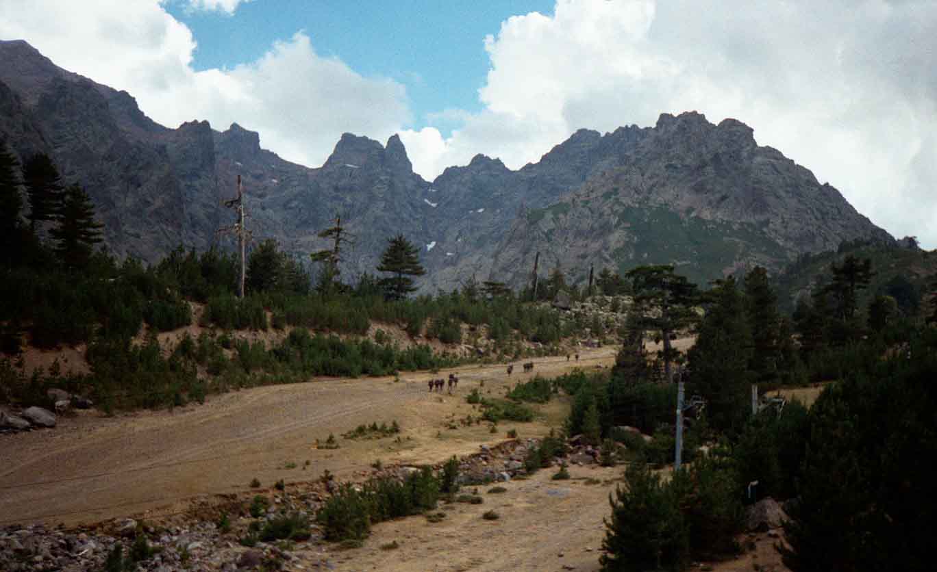
Four days into our trip found us in the heart of Corsica's hot interior. For various reasons we left it late in the season for our visit so we were walking into August, long after any lingering snow patches had melted away and the streams were reduced to a trickle. Vegetation was also dried up and brown and any pools of standing water were either greatly reduced or gone altogether. I think it was also a sustained heat wave on an already hot Mediterranean island during our trip as not a cloud troubled the sky all the time we were there and it never rained once. Campsites were reduced to dust bowls and I'm wearing a dripping wet towel on my head to try and stave off passing out before my daily cold shower hopefully revives me. It was easily the hottest backpacking trip I've ever undertaken.
The reason I mention this is that I,m including a wonderful video at the end, of the same trip over the same mountains but in that journey, taken a month earlier, there are large snow patches under the high summits, it's very lush and green, and all the streams have abundant water in them. It could be two different countries entirely but going by the cloud cover in the video it may well have rained by mid afternoon some of the days which can be a typical weather pattern over European mountain regions in summer with late afternoon thunderstorms building up. Although I like the heat normally, this was under the grill temperatures every day from sunrise to sunset.
Contemplating the route ahead. Another day of superb ridge walking.
Sometimes by mid day we had no other choice but to rest in the shade for an hour of so until either a light breeze or slightly cooler conditions prompted a move. During our trip when we descended to a stream, often there was only a dry riverbed remaining. Mostly all water had to be carried with us from hut to hut but this did keep the walker numbers down and the huts were never as busy as the video suggests on the peak season trip. Swings and roundabouts.
A photograph of the French army marching into the mountains to hunt Corsican bandits/ freedom fighters/rebels. This was the only time we witnessed troops heading off like this and with very heavy packs, twice the weight of ours, plus automatic firearms and other essential extras, I'm sure they were suffering in the heat as much as we were. The highest peak in Corsica, Monte Cinto, 2,706 metres, 8,878 feet, held only a few tiny patches of snow but in winter it falls in abundance here, hence the ski run and ski tows although the mountains are so rugged in Corsica the ski industry struggles to find suitable slopes at a reasonable angle for skiers.
At this point we came across our first road since starting the walk and Shime decided he'd had enough. He wasn't a rock climber back in Scotland and didn't fancy the notorious scramble across the Cirque de la Solitude which came next but as we were staying overnight in this road end hut, due to the small campsite being full with normal road tourists, we still had some time together.
In the morning, Scott and Gavin decided they had to climb the highest summit, which was a full 7 hour day but the rest of us didn't fancy it and had a relaxing rest, reading books and festering around in the valley, in the shade. They came back absolutely shattered and there was no way they were doing another stage the same day.
We also said goodbye to Shime (pronounced Shimmy) who was leaving the
mountains behind and heading for the topless beaches and bars instead.
He would go on to explore more of Corsica than us but only at low level,
travelling around the coastal resorts by foot and local bus.
Day Five therefore saw us setting off again to do the hardest day of the trip... in a scrambling sense. The GR20 at this point crosses a hanging wall of rock between two peaks with the aid of ladders, chains and mild via ferrata. Early in the season under snow or in rain this would be difficult but with our rock climbing background we didn't find it too hard and even worked in a few off route variations onto minor summits.
No chains up this one but the packs were left behind to climb it.
More chains on a long uphill traverse. The main difficulty was the size and weight of the packs, pulling you off balance.
Going up was fairly easy though tiring. Coming down was a different matter as for some strange reason the chains and wires ended, leaving a considerable drop down a steep rock wall which had to be scrambled without any help whatsoever... unless the situation has changed since then. This was an oddity I noticed in the Dolomites as well with back packing trails carefully chained for heavily laden walkers going up and sod all going back down when your are off balance on tiny ledges and really need them. A puzzle. If you slipped or fell with a heavy pack on here, there would be little chance of stopping yourself and you might well take others with you on the way down.
More descending. At least it was in the shade, being close to vertical in places.
One of the huts we stayed at. Camping was allowed here, which we did, but it also had a great under level for campers use that you could actually bivi under out of bad weather with a sink and basic camping facilities. A great idea.
Same hut showing the under level and tents. Some of the mountain peaks in this vicinity around the hut were ridiculously steep. Like natural skyscrapers soaring above us.
A normal Corsican peak.
A crazy Corsican peak. This one was so steep and vertical it made you dizzy looking upwards. Hundreds of feet into the air and hardly a break in it. Normally, the natural world doesn't produce
a vertical surface as smooth and steep as this one. Even climbing it with ropes would be intimidating. This photo doesn't do it justice at all as you get no idea of the height involved. Mind blowing.
Later on in the trip Gavin and I climbed the second highest mountain in Corsica on Day Nine, which was Monte Rotondu, 2,622metres, 8,602 feet. This was only a four hour climb from our tents and had the benefit of several large rock bowls, one of which held Lavu Bellebone, a hidden mountain lake with a beach of pure white sand that is completely frozen over in winter.
Very interesting mountain with amazing rock scenery and good but easy scrambling, that can be avoided, if required, to reach the top. A faint path leads to the summit without any real difficulties which has an emergency hut built into the rock.
A fantastic mountain and a fitting highlight of the trip. What a holiday and great company throughout. Thanks guys. When we ended our trip by train back to the coast we passed through several sizable forest fires as the lower slopes were tinder dry, a not infrequent occurrence on Corsica seemingly, with many of the beautiful tall pine trees that cover the mountains blazing like Roman candles. A real shame for such ancient trees that had survived so many winters.
I include this link not only for all the info required but also for the amazing video of the GR 20 North,(the route we did) which is filmed and edited to a professional standard. It may be 55 minutes long but it gives you a real idea of the scenery and quality of the GR20 and it's better than most of the outdoor/ adventure programmes currently on television. The guy must work in that industry I'd imagine as its one of the most enjoyable hill walking/scrambling/travel documentaries you will see.Great music and easy going backpackers means it does not drag at any point.Well worth a look even if you have no intention of going to Corsica just for the beautiful scenery and presentation alone. It clicks full screen in HD. Sit back and enjoy. http://corsica.forhikers.com/gr20