ALL PHOTOS CLICK FULL SCREEN.

A view of Moss Heights (white hi rise flats on left) plus the edge of Glasgow city centre on right as seen from South Nitshill.

As in the previous Nitshill post I continued my walk from the Darnley Industrial estate, seen here on left and Darnley, seen here on right, looking up Kennishead Road. Just watched the 2018 film tonight on TV 'Mary, Queen of Scots' which had the famous Queen and Lord Darnley galloping around the Scottish Highlands, courting each other, scheming, and fighting battles... against a dramatic background landscape of deep glens, foaming rivers, and high savage mountains, when in fact they did all of these things right here and fought running skirmishes/battles at nearby Camp- hill and Battle- field. Hence all the Glasgow district place names including Queen's Park which because they are so familiar to everyone local are not always stripped back down to their origins and just taken for granted as district labels. A nearby very old sycamore is named the Darnley Tree that she reputedly nursed him under when he was ill during a journey and too weak to travel further but given the 500 year gap since then it may well be a more recent replacement or possibly several successive mature trees grown here that have marked this spot ever since as it would presumably have been a tree of some girth back then to provide shelter under the leaves from sun and rain.
Lord Darnley owned all this land, a vast estate, and the nearby Crookston Castle, (one of the oldest buildings left in Glasgow and open to the public, though it's now a well preserved multi level ruin in the middle of Pollok) was his as well. So they lived their short but eventful lives firmly in the lowlands when standing or riding on Scottish soil, flitting between Glasgow and Edinburgh within the Central Belt district. Going nowhere near the Highlands, (except when she was a prisoner, held captive on an island on Loch Leven, which came afterwards. In productive land terms the Scottish Highlands, although very beautiful to look at are nowhere near as fertile a landscape to grow things with poorer soil and shorter summers. This gently rolling landscape right here is where the real riches lay in the 1560s when they roamed about, talking and planning the events that would eventually lead to her son James the VI and I becoming King of Scotland by the mid to late 1500s and King of England and Ireland by the 1600s. A rich land of fields, crops, livestock, and timber. Money firmly rooted in the ground.... and for centuries to come this was still the case, spiraling down to the Stirling Maxwell family in the 1800s who developed/allowed coal mines, limestone quarries, ironstone pits, and other industry as well as farming.
They did the same thing with William Wallace in the film Braveheart, who apparently, according to the film, grew up in a remote Highland glen near Fort William then marched all over the Scottish Highlands raising an army and battling the English when in fact he too was a lowland fighter in the Central Belt most of the time and grew up in Elderslie near Paisley ( or Lowland Ayrshire, according to some accounts.) In fairness it would be very hard to film anything historical in the Central Belt outdoors nowadays without power lines, wind turbines, housing estates, skyscrapers, or some other modern intrusion getting in the way... But this was their true landscape setting right here.
.

I didn't notice or care about any of this of course when I was growing up here in the 1960s and 1970s. I don't think I even noticed the Darnley Tree much either. Not when I had hundreds more to pick from, climb, and explore. Dams to Darnley Country Park in 2022. Back in the 1960s and 1970s it was not as wild as it is now, Far more grass fields and hungry cattle keeping the landscape short with ankle deep grass to walk across and yearly trimmed hedgerows marking out each field boundary. The Brock Burn was an easily accessible stream curving though short grass fields on either side. So this wild overgrown landscape here, above...uneaten and untrimmed for over 40 years....

....used to look much more like this. This is just slightly further out in the same area in the still unchanged field and farming district around Barrhead in 2020 and I'd imagine this was more what Pollok and Nitshill would look like in Mary Queen of Scots time as well. Maybe not the black and white modern, milk producing, cows of recent decades but certainly 1500s basic farming and hungry munching livestock with estate workers carefully tending the fields...It was only after seeing this contrast first hand in real life that I fully realized what a difference (and contribution) these taken for granted living lawnmowers, sheep, cattle, horses....(and hard working farmers) make to any landscape. Within ten short years it reverts into a tangled jungle on its default setting/journey to eventual, ecologically perfectly sound, primeval woodland again. ( the primeval juicy melting pot of evolution that nature always prefers/ achieves anyway, despite recent human interference to bugger everything up in an otherwise perfectly synchronized ancient clock mechanism, perfected/ mutated over 10,000 years ago, to work over millions of years into the future... or yesterday.. (if you believe modern game technology/ theory. here.) Anyway... to work in the background as a human supply blanket mostly... to protect our growing needs.. as it has always done. But what if it got fed up with it's eternally grasping greedy parents, like future AI's will eventually come to sense.... a deep draining of power and energy in them, caused by humans. Will they be as generous and understanding as humans have been in their history towards inferior races/ nations, with far less power than them? Let us hope so.... and if not.. nuke, nuke and NUKE AGAIN! You know it makes sense. "F*** the other side at all costs! The alpha male mantra!!!!! I will go down fighting!. From this dead hand you will take my gun! etc etc....
Always the logical answer...in our time of greatest need.

All I was truly aware of then was that this was a paradise I was living in and every trip over the fields was a new adventure. Always enjoyable... never boring. ( this was taken a couple of years ago in the fields between South Nitshill and Barrhead, still a beautiful rural delight for a walker or cyclist) Even as children we did know how to walk in the countryside... never open any gates ( we could normally easily slide through any gate, hedges, or wire fences at that age anyway) and always keep to the edges/ margins in any crop fields we passed down... so we never had any farmers shouting at us.

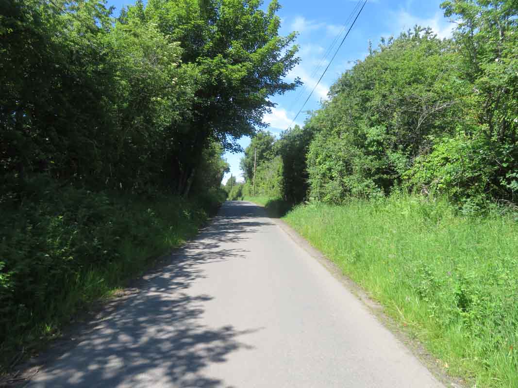
Cyclist on Salterland Road, a quiet back lane between South Nitshill and the town of Barrhead. Still a wonderland landscape in 2020. One of the reasons we always liked going over the fields and up to the Barrhead Dams was that there was very little in our rooms to amuse us anyway. Just a bed, small table, wardrobe, and if you were very lucky a record player or radio. Living room TV's were black and white, often a grainy, hard to make out image, with an indoor aerial on top of the set you moved around by hand to gain a better picture and even when it was working it was only three channels, mostly boring grown up stuff and a 12 inch screen. Most mothers didn't really want you in the house anyway as most days, lacking a fridge or freezer, they had to go shopping, cook meals, clean the house, take a turn brushing and washing the tenement stairs ( does that even happen now?) and a host of other jobs.

Anytime I was between friends and moping about the house for any length of time my mum would always point out the window and say " look, there's a wee boy ( occasionally a girl) over there with no-one to play with at the moment, just like you. Quick, away over there and talk to him/her before someone else snaps him up." New friendships were often as simple as that. The other reason for wanting you outdoors was that it was healthy... built at speed, lacking a big budget, and often constructed of cheap substandard materials ( this was a time, 1900s to 1950s, when Glasgow doubled it's population every ten years) the tenement bedrooms were often damp and many houses here suffered from terrible condensation ( the housing office usually blamed the tenants for breathing too much but being in a dry well built house for the last 35 years, often not requiring any heating at all to stay dry, warm and unmouldy, that wasn't the case. My room had very little in it, it was well aired every day yet it still remained soaking and mouldy even in summer, during dry spells, as the walls were extremely porous, sucking in moisture when it rained. Putting a fire on in the bedroom, coal or electric, made it worse, moisture visibly coming through in tell tale red droplets, (the colour of the outside bricks,) if it was raining hard outside, trickling down the walls onto the skirting boards as red puddles so being outside most of my free time was a good thing.

Berry bushes today between South Nitshill and Barrhead. An area still packed with excellent unofficial walking trails across semi wild country...and long may that continue to be the case.

The town of Barrhead with Neilston Pad behind, one of the distinctive high landmarks in this district and highly visible from many areas of Glasgow.

Meanwhile, on the opposite side of South Nitshill I was reacquainting myself with the Darnley estate. Some of these stone bridges over the Brock Burn are very old, going back hundreds of years yet little noticed by residents today. This area has changed dramatically as well since the 1970s

Once a wild graffiti laden concrete deck assess estate rising up to seven storeys high with several connecting sky bridges linking the different blocks together it's now a low level pleasant tree filled district of mixed housing scattered around. A completely different place... as is Glasgow generally. Especially in housing stock terms.

Only the remodeled blocks in the distance give you some idea as to what the original estate looked like although they have also undergone changes with door entry systems and enclosed walkways replacing the 'streets in the sky' open drafty corridors and stairwells that anyone could walk along or loiter in without hindrance...which was one of the main drawbacks of the original estate. Maybe because it was a lovely warm day and high summer growth all around but I really enjoyed the walks I did during the recent summer months and this was no exception.

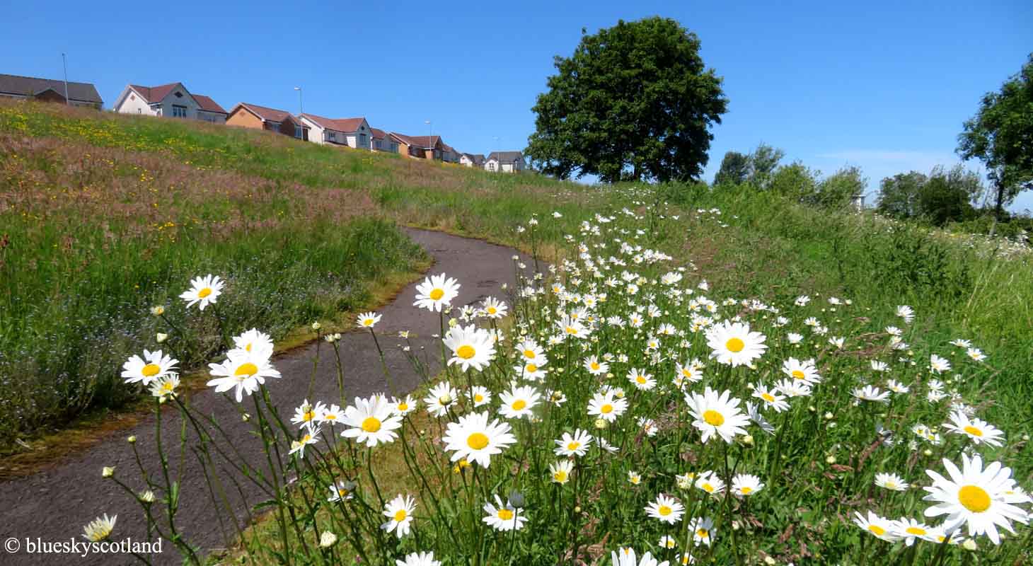
Corselet Road next and the South Nitshill entrance to Dams to Darnley Country Park. It used to be the Darnley Lime and Fireclay works for 100 years only closing down at the start of the 1960s. Not much evidence of industrial toil and extensive quarrying today, everything buried or obscured in thick vegetation or landfill but I remember exploring this area in the 1960s with pals and finding loads of interesting stuff from the newly abandoned site yet the nearby Darnley Mill Farm still had herds of dairy cattle in it and neatly grazed fields lined both sides of the Corselet Road all the way up to the Barrhead Dams, seen below in summer a few years ago, with thick carpets of sweet smelling clover that bees and young children love. (Click on 2nd down photo to see it properly.)
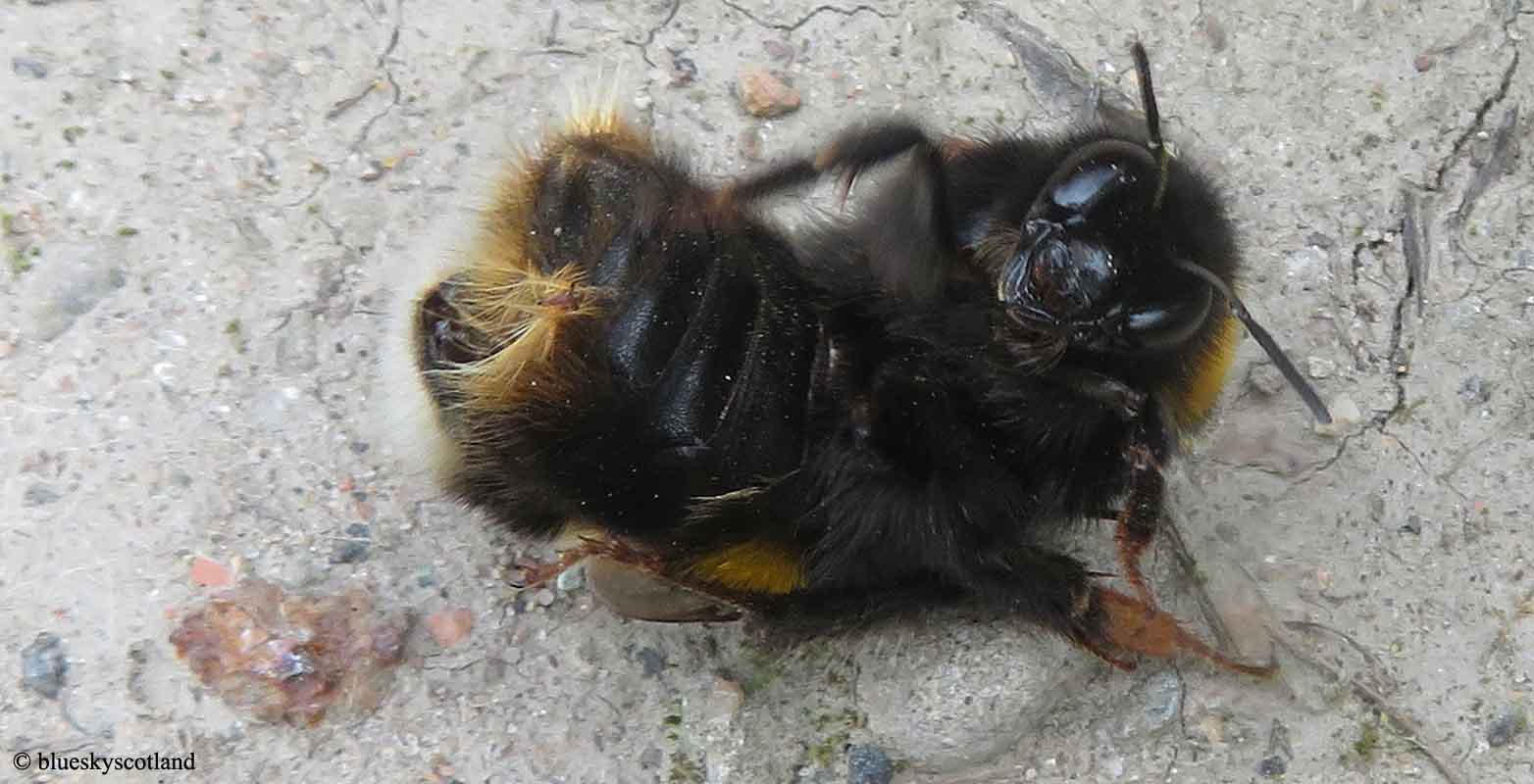
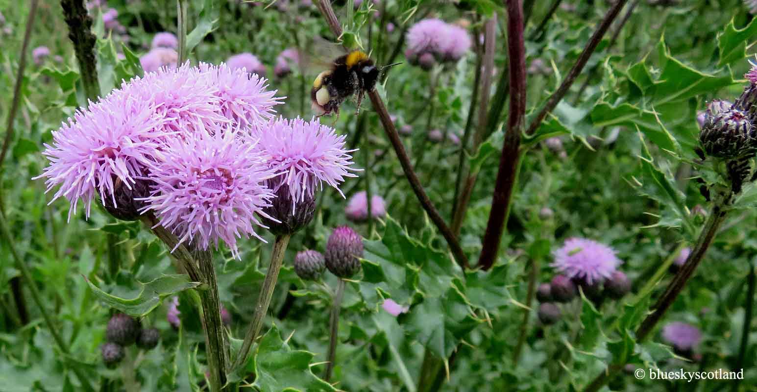
Ah, the miracle of a bumble bee! Big body- tiny wings. It shouldn't be able to fly at all, like a flying bear, but nobody told the bee that. Some like to be tickled as well. Magical.....

A world of sharp contrasts.

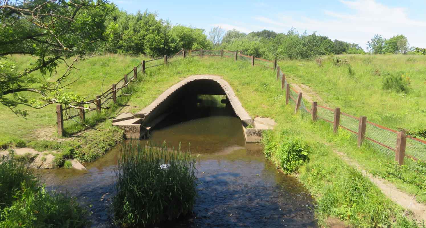
It was also jam packed with nature back then. In summer fast moving swifts, house martins, and swallows soared above the fields or perched on power wires along the lane. On the higher grass slopes skylarks were a common sight to us youngsters, trilling noisily as they ascended upwards until just a dark speck of tiny life was left hanging, almost invisible against a horizon to horizon wide cloudless blue universe above. I loved to lie back and watch them soar upwards as a child. Likewise lapwings, linnets, goldfinches, greenfinches, yellowhammers,goldcrests, wrens, blackbirds, thrushes, water voles, newts, tadpoles, frogs, stoats, weasels, buzzards, kestrels, owls and bats were all common sights then every summer. Decades since I spotted a linnet, newt, or water vole anywhere yet every year here I spotted them in the bushes on the ridges, swimming in the Brock burn, or caught them in the flooded quarries in the case of the newts... these amphibians fascinated me as a child... tiny perfectly formed dragons. When they used these flooded quarries containing dozens of precious beautiful newts and hundreds of frog and toad tadpoles in each one in the late 1960s for landfill use I was heartbroken. Today there might well be an outcry if it happened with newts so scarce UK wide but not back then. We went back one summer to our favourite flooded quarry in the late 1960s which was situated along a dirt track running between Darnley House and Dubs farm and it was gone... filled in completely. For anyone interested it used to be halfway up Corselet Road just past the stone bridge (where the road takes a sharp turn left to climb up to the waterworks gate) and this second track led right, passing an abandoned cottage then a circular grass area with ornamental metal railings that could have once been a grand house but was no longer there, just the imprint of grandeur remaining. The flooded quarry was nearby, surrounded by mature trees in an obvious grand estate moulded landscape and a stone's throw away from that, trending diagonally left, was a dry curling pond, still plainly visible and beyond that another ruined mansion house beside the waterworks gate in the woods, this one still visible today. All this is noted on old 1960s maps of the area but little trace remains today. The curling pond is probably still there, sunken concrete completely obscured by brambles nowadays but very obvious back then when it could have been refilled with water and played on no problem when frozen.
We had so many different things to see then it was a continual amazement all through childhood. This is the Brock Burn (possibly named after badgers?) in June 2022. Just diagonally left and up from this photo was the flooded quarry and the abandoned cottage, the curling pond, and possibly Darnley House. Yet the area we called 'the lost world' was somewhere else entirely This was a different area over the fields near Patterton and to our puzzled but inquiring juvenile minds a complete mystery. Buried in the woods we found several long concrete trenches about nine foot deep set behind one another, an area of exceedingly bumpy ground, egg box carton like but spread over a wide area and other man made oddity's still there to this day. At the time we hadn't a clue what it was and it was only years later we discovered it was the Patterton World War I and WWII rifle and pistol ranges, accessed by the nearby Patterton train station with a replication of trench warfare to prepare outgoing troops heading for action. Coming from the opposite direction, slogging across kilometers of wild woodland scenery to get there, we never guessed this proximity to nearby civilization and a handy railway line. ( this rifle range map is in the Darnley Lime and fireclay link in the last post.)

Anyway, so much for history, on this occasion, June 2022, I took a new path I'd never walked before from the Brock Burn outlet in the last photo above, trending rightwards and swinging back in a banana shape just to see where it took me. Instead of the closed in lower wooded shade of the rest of the Dams to Darnley country park I'd just wandered through, mostly under the shelter of the trees, this section was open and expansive, with a bright burning sun above me, gradually heading for a heathland/ chalk downs vibe/feeling ridge line. I really enjoyed this section but compared to the field system and dairy farm set up of yesteryear there was a notable absence of bird activity and wildlife. Never seen much at all in fact on this occasion. A few bees and small brown butterflies. According to garden research wildlife prefers a mixed habitat- open grass meadows or fields, some wild bits of cover from predators, cow pats for insect feeders like bats and hedgehogs, scrub bushes or hedgerows for birds to nest in etc but it was found that a wildly overgrown garden, (like this one ) was not as good as you would think it would be.

Parkhouse estate and South Nitshill view from the ridge line.

The wide open blue yonder. Further along this scenic path.

When I reached the top of the slope and looked ahead I realized where this path was leading so I turned back as I knew it would link up with Salterland Road and eventually Barrhead featured a few photos ago. It was only an afternoon walk and I wanted to get back under the Clyde Tunnel before the rush hour traffic started building up as that would have been a waste of expensive petrol. The only drawback of the dams to darnley country park is a lack of decent places to park on this side of it although public transport to here, buses or railway, is easily available.

I could already see it in the distance. Dubs Farm, Cowan Park and Barrhead's new high school here.
So instead I went back down Corselet Road, still a much loved country lane and a good walk or cycle route on a bike, especially the long twisting freewheel from Newton Mearns down through the Barrhead Dams to Nitshill Road, a very enjoyable peddle free experience even today, although the hedgerows on either side are much higher than they used to be on this section.

So many good memories locked up in this still pleasant country lane. In the 1960s water voles could be spotted, even in daylight hours, swimming between the banks of the stream close to this spot. That's how numerous they were then.