Just back after a wee holiday with my favourite flirty female, 'Belle.' Enjoyed it immensely and didn't miss the blog at all- a sign that there is a world away from computers and a life lived online.
Anyway, back to boy's stuff now. This is a day trip from a few weeks ago when overnight temperatures fell to minus ten degrees but it was dry and sunny during the daytime. This is frost on the windscreen- inside the car. Takes me right back to my bedroom in Pollok in the 1950s before central heating appeared in council homes when many bedrooms in winter looked like this. We did have a coal fire but only in the living room at the other end of the house and if you left a glass of water on the bedroom window sill overnight it would have a thin film of ice on it by morning during a severe winter. Always loved that effect... but not the freezing cold indoors. It was metal framed windows and single panes of glass coupled with severe condensation problems inside due to cheap building materials at the lowest possible cost when most European cities were tight for cash after the Second World War.
Dumyat, 418 metres, just to the east of Stirling was our destination. This rocky and steep little peak, sitting directly above Stirling University campus, may be one of the smaller summits in the Ochil Hills range but what it lacks in height it makes up for in character and attitude. Alan had never walked anywhere in the Ochils before and I was more than happy to go back to this fine range of hills as they are delightful. Frozen bramble leaves above. Alan's dog was with us as usual.
Ben Lomond from Dumyat. We parked in the free car park under Dumyat, just east of the former goat milk spa village of Blairlogie- a novelty tourist resort in the Victorian era and still thriving today... only minus the goats and the milk.
After a steep climb up a wooded gorge we came to a faint trail branching off the main path. I found this route years ago and it's still a cracker today. Whereas most folk head up the gorge to a easy level section then an uninspiring ascent to the summit slopes this path trends right at the first opportunity, weaving a cunning line between vertical cliffs on the steep front face. It's not that exposed and it's really just an airy walk or balcony trail with little in the way of scrambling but it is highly enjoyable with magnificent views over the flat flood plain stretching out into the distance, dotted with little towns and villages. Not a place to have a stumble though and care should be taken on this sheep trail that you follow as it is very narrow in places with steep drops below.
After half a kilometer or so of pleasant sideways travel across the front face, skirting between the cliffs, an obvious opportunity arises to follow several easy grass gullies to the upper tier, avoiding any scrambling or vertical walls and staying on the grass. By now you have left the path behind but just keep weaving upwards until you reach a higher level of flat ground. From here the summit should be visible on a clear day and it's a simple broad track now (the normal tourist route) to the top.
As this is the rockiest peak in the Ochil range with steep cliffs all along its southern flank we were treated to close up views of the local ravens.
Beautiful birds and like all the corvids, highly intelligent. They can communicate with each other and with other animals like foxes, wolves and wolverines, often using predators to kill meat for them by pointing out prey animals deliberately in winter from an elevated vantage point then getting a share of the bounty once the larger toothed predator has dispatched the victim and done the hard work of opening up the body.
It was a calm still day and any smoke or steam from chimneys lingered long in the air before eventually dissipating. A pastel paradise.
This white halo effect was actually just smoke from a small garden fire and a couple burning cleared vegetation in a minor scale operation, but it drifted for miles over the flood plain like a gently flowing snake of silvery substance with a life all its own. The River Forth in the distance.
River Forth getting wider around Kincardine.
A zoom of a microlight aircraft and the power station chimney.
Wallace Monument at Stirling. An iconic tower that could easily double for Dracula's Castle.
And a wider view of Stirling Castle behind and the wooded ridges they sit on.
Good beat, great song, stunning voice. Pop perfection. Posted for a girl who always loves colour, imagination, bright sunshine, and sparkling new ideas as much as I do. "Je vois la vie en rose."
ALL PHOTOS CLICK FULL SCREEN
As I've been travelling into Glasgow City Centre for the past two weeks I've had plenty of opportunity to photograph Glasgow's Christmas lights so here's a gallery. It's dark by 4:00pm now in Glasgow and only gets light again 16 hours later so the lights add some much needed cheer to the winter chill. Royal Exchange Square above, The Goma (Gallery of Modern Art), and the Golden Mesh, which is a great idea. Usual traffic cone placed firmly on the head of the statue on horseback (The Duke of Wellington) for reasons few can work out. Now well known for it being there despite council efforts to remove it. (Don't ask... it's a Glasgow thing that only started around 30 to 40 years ago)
Another view of the Golden Mesh. This Goma building (in green and blue, photo above) used to be the grand town mansion of a tobacco lord- the billionaires of their day in the 18th century and many of Glasgow's city streets are named after them or the American states and plantations that made them so rich. You can tell by the opulence of this massive building, constructed for one family and servants, that trade was good.
The Golden Mesh from the other side.
Looking out at the front entrance into Queen Street.
Buchanan Street next and the heart of the 'Style Mile.' Reputedly Glasgow still has the biggest city centre shopping district outside of London in the UK- a legacy of its 'Second City of the British Empire' industrial past. Nowadays, like many other town centres competing against the internet, the shops are either high end expensive stores or cheap discount outlets and pound shops with not much in between these two types of business, neatly summing up in concrete form the ever increasing social divide in the UK. This is Princes Square at the bottom of Buchanan Street. Visited it once when it opened just to see the place out of curiosity but didn't buy anything :o) It's not really mean spirits on my part- as I get all the thrills and kicks I need from the great outdoors...and would rather spend my money on that these days.
Frasers next door, right across the pavement facing Princes Square. I have been in here a few times when I was young and bought a gold painted and decorated jar of honey once ( very nice it was. A Christmas gift for 'Sarah') but haven't been in here for at least 20 years. Some parts of Glasgow are little known to me now and this is one as I'm not a shopping person for any overpriced luxury items these days. At my age I'm happily out the habit of visiting expensive places for the fun or novelty of it I suppose. ... but I do like the lights.
Very glitzy.
George Square traditionally has the main display of Christmas lights and festivities. They just changed them this year from illuminated hanging bells moving back and forth, although silent thankfully, to this years model- Christmas trees and hanging snow flakes. A nice change as the old ones were up for many year's in a row. Although Edinburgh is a smaller city than Glasgow it seems to have a more affluent population and has more showmanship, resources and diversity with its Christmas lights- going by my own observations over the last decade. Many years ago many of Glasgow's richest citizens moved out to suburbs just beyond the city boundary line in areas like Milngavie, Bearsden, Clarkston and Newton Mearns so most of the city's income collected over the years has lost some of that top percentage.
Glasgow City Chambers and hanging snowflakes.
Pedestrian Bridge over the River Clyde. One advantage Glasgow has over its east coast rival 30 miles away on the Firth of Forth (Edinburgh) is the mighty River Clyde flowing through the heart of the beating city. This is great for reflections day or night and a walk along the banks of the Clyde in early evening with the lights coming on and the darkness looming is a real highlight.
Another of the city centre and Jurys Inn Hotel beside Central Station.(main railway terminal)
The new City of Glasgow College and Glasgow Central Mosque reflecting in the River. Merry Christmas and a Happy New Year to All. Best Wishes for 2017.
And a brilliant and appropriate video to end with. One of the main highlights of the festive television period a few years ago for me was an unexpected look at Britain's ancient winter traditions and celebrations, many with pre- christian roots." A Very English Winter by The Unthanks." Weird and wonderful stuff and the visual highlight was the completely mad mayhem and near anarchy of the famous Lewes bonfire celebrations in Sussex. Health and safety experts look away now :o) This is TV gold from Northumbrian folk singing sisters Rachel and Becky Unthank. If it's on again over Christmas it's a programme well worth seeing in full. Here's a short taster. Had to link direct into You Tube for this but it is worth watching. https://youtu.be/KoPknsPvCL0
ALL PHOTOS CLICK FULL SCREEN
Fife this time... over on the East Coast across the Firth of Forth from Edinburgh. Last Sunday's walk with Alan and his dog was really enjoyable. A very varied walk in excellent conditions that I've done a few times before over the years was improved even more by low tide occurring at 9:30am. We arrived in Burntisland's wide and spacious excellent free car park around 10:30am to be greeted with this view of the beach. A lovely sunny day and low tide levels with a view of the Black Rocks, a tidal lump of jagged dolerite sitting a kilometre out into the bay, and all around what looked like miles of empty sand. (You can also see the high level route back inland here.)
A curlew on the beach. Normally, on the other occasions I've been here to do this amazing walk, the mini mountain rising steeply above the town commands all the attention so I've headed for that first. Four hours later I've been over the Binn Summit, a volcanic plug at a mere 193 metres high (632 feet) but which appears far higher- like a tiny Rock of Gibraltar and then I've continued on down the spine of the lower hills into Kinghorn, a few miles further up the coast.
This time though we could actually see an easy clear path out to the Black Rocks and as neither of us had explored them we headed for there. It was a hazy pastel tinted morning as overnight temperatures had fallen below zero but the early mist, ice and fog should burn away by lunchtime, according to the weather forecast. Isn't science wonderful? I consult it all the time, as any intelligent person would you would think? As you can see here the rocks rise around 8 to 10 feet high next to this dog walker.
And this is them in the middle of the bay with the tide coming in and only the highest part visible. I'd imagine in certain conditions they would be washed over completely but I've always had a mad notion to spend a night out here. Potentially dangerous though I'd imagine, if not fatal in rough sea conditions. This is a view from the Binn summit, a steep volcanic plug with grass fields and rolling farmland on the inland side and plunging cliffs of eroded basalt on the other, seaward side. Judging by the level here it might well be over 8 foot deep at full high tide around the islands with strong currents to be taken into account as well. I tried to walk over to them once as a child on holiday, around 10 or 12 years of age, but the sea was coming in fast and I lost my nerve and turned back just short of reaching them.
A dream finally realized as although I've done this favourite five star classic walk around five times now, (usually in December as it's a real sun trap) it's always been Binn first, then Kinghorn then beach.... by which time it's been full high tide and an adventurous boulder hop beside the railway line on the tiny strip remaining free of the waves in the near dark. Trust me... if you can get the tides right pick the beach and Black Rocks first! It's much easier. This is a view from the rocks over to the village of Kinghorn, around a mile and a half away. (or two kilometres) We would be heading there next but first we started walking out across the sands to the very edge of the Firth of Forth. This beach walk really is a cracker and not that busy... only a few dog walkers and a lone jogger so fantastic for photography. When any beach gets too busy it soon loses its appeal for me but this one was perfect. Those folk not keen on the full circuit over the ridge line could just do the low tide beach walk... then explore Kinghorn and return via the flat pavement on the A921 crossing over the railway by several available bridges... the last bridge being reached from the beach near another Kinghorn seafront caravan site to the west of that town. Three different walking options there and all equally enjoyable. Boots or wellies advisable to avoid wet feet and safe enough for children if they are with an adult.
A lone jogger on the edge of the Firth of Forth with Inchkeith (a remote and hard to reach island) in the distance. This was where we were heading next as nothing beats that feeling of being able to walk out into a major estuary at low tide as far as you can possibly go. A King Canute moment of stepping across the sands further and further out into the unknown where only mermaids should rightfully be.
Dog and oil rig platform. Firth of Forth.
Dead seal found at the Black Rocks. Judging by the neat cut line through the body this has been hit by a propeller of some sort or maybe sliced open for some reason with a blade to find out how it died. It did have a tag on it. Number 75258 for anyone interested. It seems too neat a cut to be natural.
Alan walking out to the furthest edge of the land. Burntisland was once a major shipbuilding town and also important for coal and shale oil deposits in the past. It still has a semi industrial feel about it in places and has an important engineering and fabrication yard for the oil and gas industry still operating at the docks to this day which is maybe why three oil rig platforms could be seen offshore in the Firth of Forth and also several large ships. Either that or they are static here due to the downturn in the oil industry at present. The East Coast has a completely different feel to the Scottish West Coast, different landscapes and look about it- half the rainfall levels- a great deal more sunshine- and I've always loved coming here. Burntisland itself is an interesting place for day trips with lovely beach walks, historic D.I.Y town trail, many unusual buildings, a nice park, and of course the Binn.
A view of the main street from the car park and meadows area. Ladies and gents toilets are just to the left of this photo and a decent chip shop sits across from the car. All you really need for a great day out.
A fine church in Burntisland viewed from the beach front. Sheltered seating and a short but enjoyable concrete promenade walk here. The path up the Binn can be found on the A909 at Silverbarton where a signposted hole in the wall is found just past the last house on the upper left side of the town's outskirts.
A Redshank, a small wading bird usually found on beaches and estuaries in the winter months when the ground inland is frozen hard and no use for finding worms and grubs with its long probing bill.
We also noticed on the walk across the sands to Kinghorn the remains of hundreds of wooden posts sticking out the ground in long rows. Only the tips of these were visible, heavily eroded and we speculated they might be low tide piers of some sort or even medieval fish traps. After talking to a local however he informed us they were built during the war to stop German planes landing on this flat expanse of sand. Any plane landing when they were at full height might have had their wings chopped off running along the beach.
A very different walk and my new favourite place. All my photographic guidebooks on Kindle tend to be areas of Scotland like this, unfashionable but really scenic and unusual, off the beaten track, so with Christmas coming they might be worth a couple of quid as a present as they all highlight a range of unusual places to visit in Scotland, like this one. Welcome to the Fife Riviera.
From Kinghorn, which is an interesting wee place as well, we walked up through sunny streets named after kings and great locals then passed glorious beaches like this one. Both Burntisland and Kinghorn lie on the route of the long distance Fife Coastal Path which is a gem in itself. Many years ago, after finishing the Munros, I started collecting beaches all over the UK... 'Captain Coastwalk' was my somewhat derogatory nickname then, bestowed by my amused mountaineering friends who showed no inclination to join me on my travels... long before that in my teens (as hinted at in my first book Autohighography) I collected humans... again from all over the UK... before that, in childhood, I was an egg collector... at least the eggs stayed put where I placed them- people prove much trickier as a rule. In short, I've always swam against the tide and popular trends, by inclination rather than any design, going my own way and picking my own pursuits.
At Kinghorn we headed inland up through this small town to the golf course then up through that and a caravan park on a right of way track past a farm (dogs on lead here) to walk past The Bents and Grangehill (on OS Landranger map 66 Edinburgh) As we climbed higher up the ridge great views opened out over the Firth of Forth but the scenery inland was not too shabby either. This is a view of Kinghorn Loch, above.
And one of a rapidly shrinking sandbar from the hillside caravan park and the beach where we walked at low tide a mere two hours before.
Ships and oil platforms moored out on the Firth of Forth near Kirkcaldy, one of the largest towns in the Kingdom of Fife, which in turn is a large hand shaped peninsula lying on the East Coast just north of Edinburgh. Shale gas ship seen here in full screen view, probably coming from or going into Grangemouth oil refinery.
A distant view of Kirkcaldy gleaming in the sunshine as viewed from the Binn.
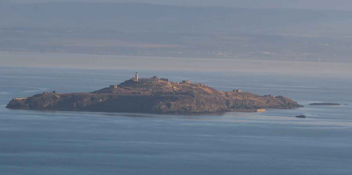
One of Inchkeith. A scattering of wonderful islands lie out in the Firth of Forth- all of them individual, well spaced apart, and uniquely different. Unless you have a private boat or you are a sea kayaker with experience in a group for safety they are hard to reach although a ferry does go out to one from Queensferry to Inchcolm in the summer months. I've visited a few, including Inchcolm, but not Inchkeith which is too far flung and dangerous for my own inflatable kayak to reach. An island I've always wondered about though. https://en.wikipedia.org/wiki/Inchkeith A fascinating history and map of the island in this link including its use as an early quarantine outpost for syphilis and other unfortunate human conditions including the extraordinarily cruel James IV's linguistic experiment which is worth a read and mind boggling.
The rolling Fife landscape behind the Binn. Although it was warm and toasty down on the suntrap sands and over most of the rising ridge line these slopes here were still in deep shade and the turf underfoot was frozen solid with no sign of a thaw.
The rocky cliffs of the Binn on the seaward side. Rock of Gibraltar comparisons? Well, when you are up here in sunshine looking down, if a few Barbary Macaques appeared on a boulder below your feet they would not seem out of place at all.
It's hard to tell you in words how good this fantastic walk is... just try it for yourself. 4 to 6 hours depending on fitness, tea-breaks and speed. We took 5 hours as it's so good it's not one to rush. Around 10 to 12 kilometres full circuit.
Good video here showing some of the other islands in the Firth of Forth. This gentleman has a collection of other interesting kayak videos on You Tube. Few things beat the feeling of an island reached by kayak.
ALL PHOTOS CLICK FULL SCREEN
As it was a two day weekend trip to the Scottish Borders I had enough photos for a second set. This is a Rhea, a large flightless bird from South America and like all its ilk it packs a powerful kick with its sharp claws. Some have escaped from farms in Germany and are now running wild there with a breeding population of over 100 birds- which is an ever present danger threatening the world today with plants, animals and spores getting everywhere they shouldn't now that travel between countries is so easy and fast, with few restrictions.
Having said that, I , like most folk, like to see the exotic and they don't come much better than this meadow in a secret location I will not name here. Rheas, Alpacas, Donkeys and Geese sharing the open ranges in a landscape not that far removed from their original homeland territories. They all seem to get on ok here together apart from the odd clumsy mishap.
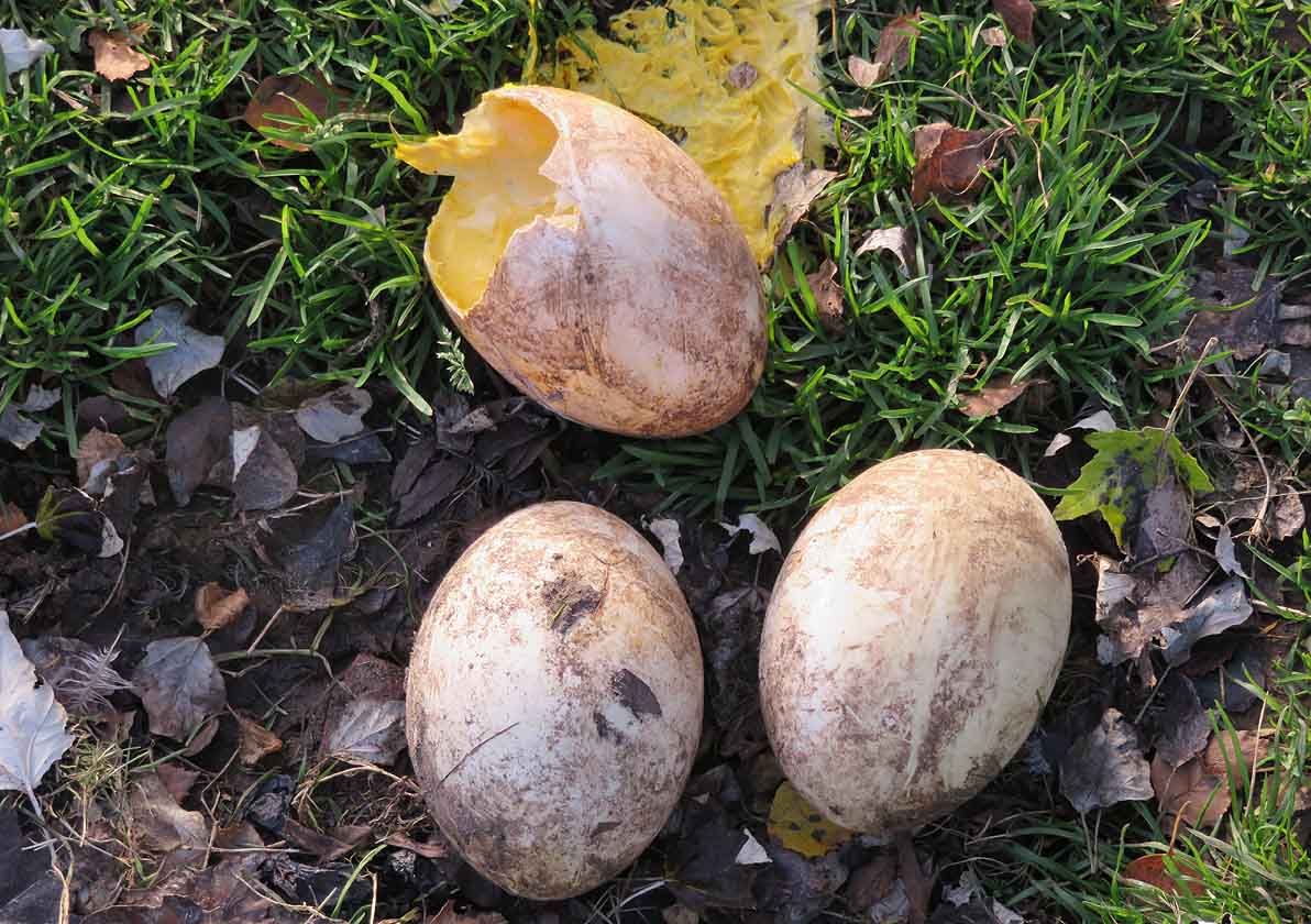
Rhea eggs with one broken. Probably a hoof rather than a predator.
Not the culprit on this occasion as it was already smashed when we arrived but a likely cause given the proximity of the eggs to the fence and folk arriving to pat the donkeys and see the animals up close. I've since learned rheas can lay up to a dozen eggs and deliberately sacrifice a few to predators while guarding the rest on a concealed nest but these rheas didn't appear to be sitting on anything elsewhere. It was November and very cold so maybe too late in the season. Also there didn't appear to be an actual lined scoop to keep the eggs insulated from the cold wet ground so they would chill down very quickly even with a bird sitting on them.
Lovely markings on this donkey.
Road sign and autumn colours.
Museums in Bigger. Although a small town/village it has several interesting museums including a puppet theatre and an old gas works that supplied the area in the past. Not many of them left in the UK.
Village in the hills. Late autumn colours.
Broughton. Not much in this small village for tourists but a favourite for interesting cycling trips with lovely scenery and several fine cycling or driving loops passing through either here or Biggar.
What the surrounding countryside looks like. Either pleasant rural farms, small woods or....
high rolling hills and moorlands...
leading up onto even higher hills with giant hog back summits and a real feeling of big wide skies and far flung horizons...
Donkey and Geese Meadows lower down.
Sheep Country.
In a bothy. Crossword puzzle.
A bothy fire.
The Southern Uplands.
Perceptions and opinions. I've been a fan of Kate Bush since we were both teenagers as I'm roughly the same age as her and I used to drive past her family house in London when I visited friends nearby and I'm well aware she came from an upmarket middle class area. Her house was one of the largest on her street even before she was famous and she has always had money and a certain privileged lifestyle, albeit with a bohemian outlook. It came as no surprise to me therefore to find she supports Theresa May and thinks she is a credit to the UK. It would be more of a surprise to find she supported anyone else given her background and it does not diminish her obvious talent in any way for me personally. What it does highlight is the gulf in thinking between those who have little and those who have a very comfortable lifestyle. A decade of ongoing austerity means nothing to them and they naturally have a very different view of the world to those on the bottom rungs. Recent soundbites from the Conservative party show that very clearly. Despite bad results in the UK and America voting for dangerous loose canon outsiders they still appear completely oblivious, re-branding themselves 'the caring party' but still implementing the usual austerity cuts wholesale to services and people telling us 'they get it' and grudgingly saying they now understand how 'we' feel. My question is- How can they when they live such a very different reality to the rest of us? It's like me saying I understand what it's like to be homeless. I live in a house at the moment so I don't.
Chalk message in an underpass frequently used by rough sleepers.
Actually, they still haven't a clue why people really voted for Brexit against all the predictions or best common sense and seem to have no inkling about the growing levels of genuine anger over inequality in this country and other places around the world where the poor have steadily became poorer year on year and the greed of the rich elite has only increased and been rewarded. In the 5th richest country in the world ( the UK actually climbed two places higher during and after a so called recession) it now costs far more in infrastructure and wages to sanction and punish the people on the bottom rungs than if you just gave them all a basic minimum universal income to live on, no questions asked, and cut out all the complicated levels of bureaucracy and stigma involved in the benefits system which is blatantly cruel, unfair, and hasn't worked properly for years now. I watched a film the other night that suggested we are rapidly going backwards as a society from even the period of 20 years ago where the ordinary folk that make up the supporting pyramid numbered roughly around 80 percent to a 20 percent top tier- which in monetary terms wasn't all that far above the masses. It's now a staggering one percent of the elite that owns more money than the other 99 percent of the population combined so something has to change. At the risk of appearing a leftist nutter, which I'm not as I can't stand politics normally and steer clear of politically motivated people in general but I've been banging on about this since the blog started, on and off.
Here's a more educated view on this same subject and a warning. Worth a read. https://www.theguardian.com/commentisfree/2016/dec/01/stephen-hawking-dangerous-time-planet-inequality
Anyone got any appetite for World War III ? Many historians believe it is coming. But will people listen in time? Did they ever listen before in the past? History gives us the answer to that as well :o(