Saturday 27 June 2020

Alta Via 2. Backpacking across Italy's Great Rollercoaster Route. Part One.


Around 10 years after doing Italy's Alta Via 1 with John and Brian I had the opportunity to do the Alta Via 2, this time with a larger group from the mountaineering club- consisting of Scott, Julian, Graham and Paul. Unlike the Alta Via 1, which once it gains elevation tries its best to stick to a level height throughout, weaving past, under, or through the various massifs it encounters ( like a mouse finding the easiest line between tall shoe boxes) the Alta Via 2 takes great delight in tackling any large mountain it encounters head on- straight up one side then straight down the other. This means a lot of extra effort and a roller coaster hike overall. Two weeks to walk 160km or around 100 miles in length, walking North to South, from near the Austrian Tyrol border at Bressanone/Brixen to Croce d' Aune, near Feltre. Close to a total ascent for the trip of 40,000 feet with a similar descent- almost 80,000 feet combined of knee grinding effort during this hike... as we climbed the Marmolada, highest peak in the Dolomites, as well.

Mountain cabins in the Dolomites. For this reason, and being the oldest in the group by 5 or 6 years, into my frisky 40s by now, I decided to strip the backpack weight right down. No gortex rain jacket, ( too heavy) no expensive via ferrata kit or climbing harness, just three lightweight slings and three lightweight screw-gate carabiners to fashion a DIY harness and V.F.kit myself, no rope, no helmet, ( I would either solo everything or just avoid any obstacles in the way, (hopefully), confident now as an Alpine and Dollies veteran I could do that.)
This is typical of the Alta Via 2- a brutal ascent up a mountain massif from the hairpin bends road pass, which in itself climbs to an impressive height. Then a short level walk through amazing mountain scenery...
then straight back down the other side. These photos are not in strict order as after 20 odd years to match them precisely as to when they occurred on the trip is asking too much from my memory but I've tried to place them roughly in sequence as a beginning, a middle, and an end.
I remember the first few days we had on this trip did not match my expectations of a sunny Dolomites. Glasgow fair fortnight again so mid July and we got similar weather here to a Scottish summer in the high mountains. A real mixed bag of elements.  Mist at all levels, glimpses of mountains, really cold mornings, sticky, humid afternoons, always damp, frequent showers. I began to regret leaving my waterproofs behind, using a black bin liner instead, but it was so uncharacteristically cold it was the extra heat of a thick jacket I was missing rather than for any rain protection.
As usual we were camping and cooking ourselves,  but usually near a mountain hut where we could head every evening to relax inside or on the veranda and get a few pleasant beers. It was a saving of around £200 doing it this way... but we also just preferred the camping life, being Scottish and used to it.
This was the height of luxury and comfort for us... a picnic table for breakfast in a valley campsite on the Alta Via 2. A low level blip in an otherwise high level hike. Time to wash clothes and socks, get showers, stock up on supplies for the next section.
Then back up into the mountains again. Still cold- still misty up here.
No idea what mountain this is... even at the time we didn't really know, summits just glimpsed occasionally and guessed at in a sea of swirling cloud.
Early morning mist in the Dolomites.
Scott spots some Alpine Ibex and takes a photo.
And then a few days into our trip the miracle we had been praying for finally happened... it cleared up... and the sun came out...
Makes all the difference when you can see the landscapes you are travelling through. And in the Dolomites they are always fantastic.        To be continued......

As we didn't really see much on the first four days of our trip here's a link to a brilliant short video of the route.
I picked this one as it highlights the fun and sheer enthusiasm of being young, having adventures together in a group, and feeling invincible and immortal at that age. You tend to forget you were ever like that when you get older and the world gets less fresh and intense to your eyes and senses.... so this is a joyful window to that past age in any human life story. Your younger self.
Link here. (In a new window for Carol)   Best watched full screen. There is no other area like the Dolomites.

Friday 19 June 2020

Gran Paradiso. Epinel. Cogne. Two weeks in Italy's Great Paradise.

Another post from the archives going back to the late 1980s period. A two week trip to Italy's Gran Paradiso National Park. We stayed at a pleasant flat grassy campsite in a side valley just off the main Valle d'Aosta in a hamlet called Epinel which had a small supermarket, a couple of hotels/bar... a campsite.... and very little else.
                                                     ALL PHOTOS CLICK FULL SCREEN
This did not matter in the slightest as the local supermarket in Epinel had nearly everything we required food and drink wise, and the larger village of Cogne, with its own campsite, green meadows, a wider range of shops, bars, and an open air market for local produce was 5 mins in a car or a half hour walk away along a traffic free leafy back trail. Cogne can feel busy and hectic though, filled with climbers and tourists, whereas Epinel is much quieter, so probably better for families with younger children to keep an eye on them in a nice open camping ground of short meadow grass.

Tiny person on a rock tower here surrounded by the beauty and majesty of  Paradiso National Park. We were here to explore and Epinel was ideal for that with a handful of  easy 10,000 foot rock peaks directly above the campsite, free from snow in mid July; (Glasgow Fair trip again) several higher 12,000 foot snow peaks, yet still remarkably easy to ascend from the campsite, and soaring high above them all... the  undisputed Queen of the Graian Alps, Gran Paradiso itself at 4,061 metres or 13,323 feet high. ( Mont Blanc, The Matterhorn, 'called Cervino in Italy', and Monte Rosa, all share a border with France or Switzerland whereas the Paradiso range lies slightly separated and isolated on a detached spur wholly within Italian soil making it the highest single mountain completely within Italy. No part of it touching another country.
It's one of the easiest of the 4,000 metre peaks in the Alps, just a long pleasant snow plod but the shattered rocky arete of the steep summit ridge lends it plenty of interest with a massive drop on the other side and fantastic views in every direction. Note the tall rock pillar just right of the summit.
This is me standing on the top of said rock pillar with the lower 12,000 foot Frontier Range of the French/ Italian border spread out below. It looked an easy if vertical scramble so I just went for it although looking at other photos of this pillar online I'm amazed it's still standing as it's only just attached to the rest of the ridge by a thin band of shattered rock. Most of it hangs over the abyss like a natural version of the leaning tower of Piza. An angle not seen in this photo, where it looks straight. I must have been taking my bravery pills that day.
Unlike Mont Blanc the view from Gran Paradiso was absolutely stunning. No pounding headache, altitude sickness, freezing cold wind, or exhaustion either. Just exhilarating, warm, and fresh so we could enjoy it in style.  A night time thunderstorm had battered our tents, pitched halfway up the mountain, but the next morning dawned calm, clear, and magnificent with cloud in all the valleys but blue sky over all the high snow peaks. No wind on this mountain at all- sunny enough to sunbathe on the summit and that summed up this trip. It's a perfect area for beginners to explore the Alps. Interesting history, castles and small towns scattered across the Vale d' Aosta area; cosmopolitan Turin around an hour's drive away; loads of scenic balcony trails and a mind boggling number of wildflower meadows, (the best I've ever seen anywhere)
One of our rest days exploring Turin. Even with 3 or 4 sightseeing days during our trip when it was flat walking we still managed to clock up 30,000 feet of ascent and descent during our holiday here. Every non rest day saw us ascending at least 3000 to 4000 feet to do one of the rock peaks or a 12,000 foot snow peak, where we camped out overnight before tackling it in the early morning.
Alpine Ibex. The Paradiso National Park and the adjoining Vanoise National Park ( see separate entry on that park a few posts ago) were set up to save the Alpine Ibex, seen here, as they were almost hunted to extinction and down to the last 60 or 70 animals. The herds wander across the Frontier Range and back so both parks protect this huge tract of mountain upland and it really does feel like a 'Great Paradise' as every other animal in this vast region benefits as well. Alpine Ibex now number close to 1000 in this region. Magnificent creatures you can get fairly close to if quiet and patient and don't spook them away.
Smaller cousins- a family of Chamois here looking down at us.
Descending the glacier on Gran Paradiso... The entire world spread out below our feet. It's not often a human feels like a demi- god but it certainly happened to me here. A truly magical place.
Punta Fenilla ridge walk in the background. A rock peak reached from Epinel.. You could not design a better set of peaks for hill-walkers than these.
This is Punta Trensenta. Both peaks, not far apart, had a long easy ramp of perfect scrambling up slabs. Nothing too hard - just glorious indulgence- like fine Italian ice cream....trust your balance and the friction of the rock, being the key.
Then it got a bit harder and steeper... but still OK... and an easier variation round the side if you required that. Still Punta Trensenta here and a beautiful crack-line of great holds, hopefully leading us to the top. A wonder slab over a 1000 foot long, scrambling every inch of it without a rope, yet never too extreme or threatening. How often does that happen on a slab that length. No guide book or idea of route or prior knowledge of any difficulties ahead. Pure adventure on rock using just hope, toes, and fingers.  Just as well as it would be far harder to reverse it for 1000 feet, but not impossible.
And perfect summits as well. The cross on Punta Fenilla here with a slab scramble to the top. ... Unbelievable climbing... airy, exciting, yet safe and the way down off both was a slightly easier descent.....
Another rock peak traverse high above Epinel completed with easy scrambling. Tiny figures in this photo can be observed walking the ridge with Cogne far below in the valley. This trio of peaks I've never bettered for sheer enjoyment. Each a 10,000 foot stunner but climbed one after another a magical experience. This whole trip was full of them. Magical moments that is.

Easy but spectacular 12,000 foot snow peaks no problem either. Punta Del Rossa here, coming off the steeply inclined summit ridge. Ice axe and crampon territory.

Want something harder? La Grivola, at 3968 metres the other giant of the range but only accessible via a severe snow and ice climb with a stonefall risk thrown in for good measure. Definitely a roped experienced party required for climbing this peak.


Or how about tackling the Mont Blanc Range from the Italian side near Courmayeur, which we also did on this trip. A failed attempt due to severe winds high up but a great day nonetheless.


Above, John on the other side of  La Grivola glacier hanging over its cliff, balanced precariously above an alpine meadow.

More Ibex seen from our tents halfway up Gran Paradiso but looking at two other snow peaks in the range- La Tresenta, 3609 metres and Ciarforon, 3640 metres... so loads to do in this area... we just scratched the surface on our trip. One area I would definitely return to as I loved this region of Italy.


A high balcony trail view of La Grivola/Paradiso range with a thunderstorm just ending. Sunlight hitting some yellow globe flowers.


Our rest day exploring Turin, admiring a typical Italian grand fountain display. A 'rest day' might be a 10 mile walk around a city, as here, but it was relatively flat. Another rest day was up Valnontey from Cogne, a pleasant valley and alpine meadow jaunt in the early morning, then sampling an open air market afternoon of shops in the village centre.
A fantastic trip and well named. It was the Great Paradise for us.... hopefully still is.

A link to a terrific short video of Gran Paradiso and the area in question. Well worth watching as it's brilliantly done and full of interest. Captures the real holiday experience overall within the National Park perfectly. A work of art in its own right.

Saturday 13 June 2020

Backpacking the Haute Route Pyrenees. Ordesa Canyon Traverse.


Another tale from the vaults. Around 30 years ago, probably Glasgow Fair fortnight again, so mid July, a group of us decided to backpack through the French Pyrenees from Gabas (Pic du Midi D'Ossau) to Monte Perdido in Spain. ( this last reputedly the highest exposed limestone summit in Europe)

                                                  ALL PHOTOS CLICK FULL SCREEN.
An overnight thunder and lightning storm here just clearing in the early morning. Practically every afternoon during this trip we had spectacular thunder and lightning storms but the good news was we had dry sunny hot days until around mid afternoon- then between 4:00pm and sometimes not until midnight all hell would break loose with biblical levels of rain, sheet and forked flashes for hours and thunder so loud it felt like shell shock. Then, in the morning, it would be sunny, clear and dry again as it was the heat build up during the day that created the slow increase in thunderclouds. As reliable as a watch. Knowing this fact allowed us to climb some of the highest and most dramatic peaks in the region and as long as we were down by 4:00pm it was fine and safe enough.

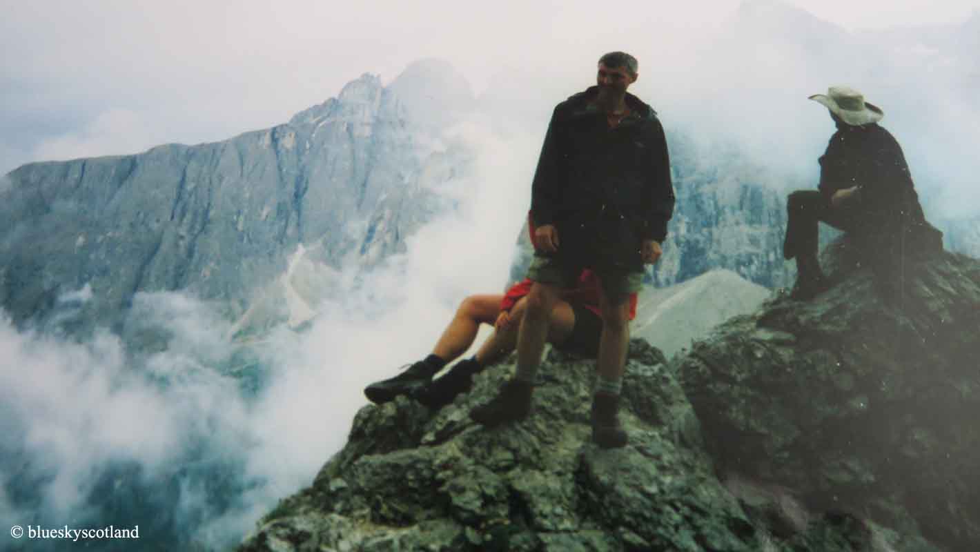
After we travelled by train from Glasgow to London then plane to Toulouse then bus to Gabas we backpacked into the  Pombie Hut, sitting in the shadow of the iconic Pic Du Midi D'Ossau, an impressive 2884 metres, 9462 foot rock tower. After a good night in the hut we went to bed in our tents and in the morning successfully climbed this imposing rock tower by a grade two scramble. Easy in ascent, slightly harder coming back down the same way. I seem to have lost my photos of it though so  the next big mountain on the Haute Route trip, above is Balaitous, 3146 metres, 10.321 feet....a huge sprawling beast of many different ridges. The full traverse of the GR10 Pyrenees chain end to end takes 50 to 60 days to hike over but we only ever had two weeks holiday so we compressed that into 10 days over the highest section in the middle part of the range. On this trip we had ropes and climbing gear with us, making  the packs exceptionally heavy- just what you want hiking along a 10,000 foot mountain range from peak to peak. This would be the last time we would take ropes and climbing gear on a backpacking trip. We would either solo mountains in future, if easy enough, or simply miss them out.
This was in the Pyrenees folder but I don't remember taking it. The scenery was very impressive, most of the route here following the French side so fairly green valleys, water in the streams for drinking, and rocky peaks above. The Spanish side of the range was usually hotter, very dry and arid looking. though still impressive.
The reason for carrying the ropes was for this peak. Vignemale, at 3298 metres, 10,820 feet, the highest Pyrenean peak on the French side. One of the guys in our club had been here previously, but a full month earlier in the season, maybe late April or early June when it had been covered in snow and ice and ropes were required to reach the summit.  Now, over a month later, and a week into our trek, we found out we no longer needed ropes or climbing gear and could ascend the small glacier with ease. All the snow had vanished under a hot sun. Small un-roped children happily scampered past us to the top, laughing at our stupidity. We certainly did not find it funny in the slightest, thinking of every incline we'd crawled up, panting and sweating buckets, over the last week with all that unnecessary weight on our backs. Luckily, the guy that had recommended taking them was safely out of reach back in Scotland. It was at this point I decided I would never take a rope on another backpacking holiday... unless it was to hang, draw and quarter, said Pyrenean experienced guide and adviser. This was back in the days before extensive research could be done over the internet in minutes where trips to libraries or climbing shops gleaned scant knowledge of the area, a few lines in a guide book if you were lucky or a grainy photograph of a mountain.... no detailed descriptions of routes at all.
Another camping spot beside a river. The day before ascending Vignemale we needed fresh food and supplies so we cut down the Vallee du Marcadau into Cauterets, a small pleasant town and vital supply hub for the Haute Route as this was the first road and settlement encountered since Gabas. Here we could get clothes and socks washed, buy food and have showers so we stayed the night here in the town campsite. Food always tastes fantastic on backpacking trips so we had hot pizza slices here- heaven compared to freeze dried noodles every night or pasta choice.
Our next major excitement was descending the slopes into Gavarnie. A very strange little French town/large village that boasted the Cirque de Gavarnie, one of the highest vertical rock bowls in the Pyrenees and also the highest waterfall in France at 422 metres, seen here.
Gavarnie, we soon found out, was donkey central, dozens of horses, mules and donkeys lined the main street, stood patiently tied up to bars outside pubs and hotels or rested in stables. It was like the wild west only with French accents. The reason for all this four footed mayhem was that Lourdes was a short bus ride away. After sampling the miracles on offer there, the big tourist draw was a trip to one of the highest villages in the Pyrenees, (Gavarnie at 1355 metres or 4445 feet) then a donkey trip around the rock bowl of the Cirque and a close up view of the falls. Cars are banned in Gavarnie but horses and donkeys still seem to be a common feature in French and Spanish mountain regions as the Italian Spaghetti westerns, that revived that genre, featured similar picturesque villages and scenery in Spain and Italy, doubling convincingly for the desert states of the USA.
The next day we set off for the Breche De Roland, a deep notch in the high vertical wall of the Cirque and a mountain pass between France and Spain. Here we would split up with some going towards Monte Perdido and others, me included, heading for Ordesa Canyon, one of the deepest gorges in Europe, yet, until this point, we had never heard of it.
We'd never heard of the Breche De Roland either, seen here descending into Spain, on the other side of the gap. According to legend this notch was carved by Roland, warrior nephew of Charlemagne the Great, King of the Franks, who found himself cornered and surrounded by enemy forces here and tried to smash his magical sword 'Durendal' against the mountain ridge rather than let it be captured as a powerful weapon for the Saracens. Even in this remote empty corner of inland Spain we found ourselves rubbing against an alternative history of Europe, like a dimly remembered folk tale. This was the ancient region of Aragon, capital city, Zaragoza, still 200 km away- names we vaguely knew and recognized but also refreshingly blank as to further information.
As we'd climbed several Pyrenean summits/mountains by now, a few of us fancied a change of scenery, and we certainly got that here. Monte Perdido above, with raw, white limestone 'rivers' flowing down it's sides. Being limestone any water, even with daily thunderstorms, drained away instantly into deep potholes and this high plateau region was very arid and dead looking.
Walking under the slopes of Monte Perdido, ( the 'lost mountain' ) reputedly the highest exposed limestone summit in Europe at 3355 metres,just over 11,000 feet high, but with thunderstorms raging daily and breaking earlier in the day, often by lunchtime, we thought a visit to Ordesa Canyon seemed a safer bet. It was hard to tell exposed bands of limestone from a small grubby glacier on this side of the breche but at one point, sheltering from lightning strikes hitting the ridge we sheltered in a large high level cavern filled with flowing ice and ice formations hanging from the roof. Completely open and rather spectacular when we visited it's now guarded by a locked gate, permission to enter required, to preserve the formations. We found out, years later, in a climbing magazine, it's the highest ice cavern in Europe.
 
The edge of Ordesa Canyon. The reason Perdido means 'the lost mountain' is apparent here. From the Spanish side it is guarded by several km deep trenches in the way, not just one, a formidable barrier before the age of maps. Our own map showed a faint dotted line leading to the edge of the canyon walls above the Spanish town of Torla, then a zig zag descent path down the mighty canyon rim to the valley far below.
It was too late in the afternoon to attempt a descent by the time we had walked to the edge so we camped here on the rim of the deepest canyon in Europe and then looked for the path leading down the 1000 metre vertical cliffs. It was a very impressive sight yet before this point we had never heard of Ordesa Canyon, or its nearby, equally impressive, sister canyons of Anisclo, Pineta, and Garganta de Escuain and have never seen them featured on TV in the 30 years since then.  I think I was about five years old when I became aware of North America's Grand Canyon- just as well really as this remarkable area remains largely unspoiled, despite being a national park and world heritage site.
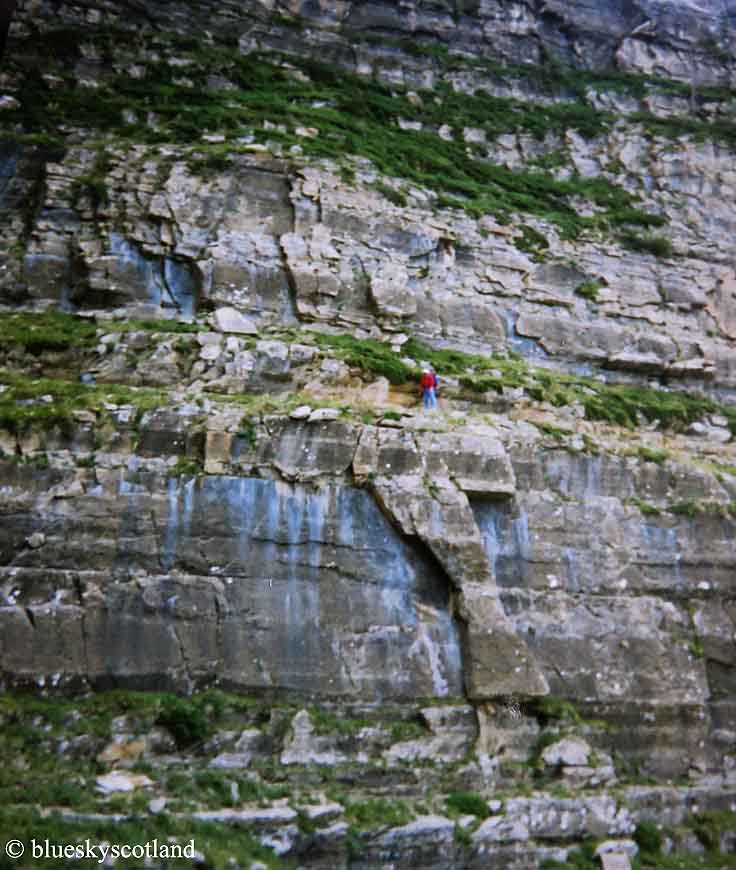
The 'great prow' of  Tozal del Mallo soaring high above Torla and a path along it only for the brave to walk. Monte Pelmo levels of exposure here- enough to turn any climbers legs and stomach to jelly yet unbelievably a few hard rock routes snake up these cliffs, including the vertical slim blade of the prow itself
The cliffs of Tozal del Mallo from below. As we were camped  on the empty plateau directly above this awesome feature we had to find a way to get down in the morning and eventually we did see a route.
The faint path on the map leading to the valley below turned out to be a hair raising descent along narrow ledges weaving between the vertical cliffs. Like Monte Pelmo, easy enough if free from any vertigo but any slip here was certain death, especially carrying a heavy suitcase on your back and by now we were tiring, a real effort each day to lift them onto our bruised shoulders.
Only adrenaline kept us safe as we moved down from one narrow ledge to another...
and luckily any vertical down climbs to a lower ledge had wire cables, seen here, for extra support. Which was just as well.
Around 3000 feet later we reached the bottom of this gorge then proceeded to climb up the other side as the plan was to access another balcony trail halfway up the opposite canyon cliffs. This path was broader, a proper tourist track with lookout views and a few very basic emergency shelters along it's 10 km length and would take us eventually back to Monte Perdido and the Breche where we would meet up with the others again.
A view from this balcony trail. We might have camped out here on the ledges but we reached the Mirador, a mountain hut, just as the daily thunder and lightning storm hit, one of the most impressive of the trip so far in its stark ferocity so we stayed there for the evening instead as biblical levels of rain fell and the sides of the canyon shook with lightning strikes, stone fall, and deafening thunder. A lucky escape.
In the morning we continued our trek to the head of the canyon, where the sides gradually shrank in size to reach the lower slopes of Monte Perdido again. Head of the canyon seen here. The balcony trail follows a line along the middle of the left hand cliff wall getting more exposed as this fabulous gorge deepens.
We then climbed to the Perdido hut under the mountain, seen here with a horse bringing up supplies (fresh melons by the look of them) and then scampered back over the Breche into France again, followed all the way by forked lightning strikes. Rather than spoil the trip these daily battles with the elements added greatly to the experience as a full blown lightning storm experienced in a tent in the remote mountains was a privilege never forgotten. Nature at it's savage best. Even inside the tent, it lit up like an X-ray with every flash. Standing outside in the dark, it was blinding, hair rising on every part of your body at times.  An epic backpacking trip in every sense.
A link here to a beautiful picture gallery of Ordesa for hiking and the other three canyons. An amazing place yet still relatively little known in the UK.