After a pleasant half hour or so we set out again. From here to the western tip of Canna the map hinted that we might be able to traverse a terrace at sea level below the cliffs. The obvious penalty clause of course is that if we couldn`t make it all the way along then we would have to retrace our steps all the way back here. The sun was roasting by now and the prospect of a low level flat walk as opposed to the up and down roller coaster along the cliff tops won out.
We had seen a hint of a golden beach in the distance earlier in the day and decided to go for that and then have a paddle to cool down. Yup...we are talking about Scotland here I can assure you
Zoomed shot of the beach...

Setting off...

Walking along the sheep track and enjoying the shade ....

For anybody else inclined to follow this route along to the beach I`ll add a route description at the end of this post. I doubt it`s ever been in any guide book.
We were forced back up the cliff just short of our goal. Out of the shade and back into the mid afternoon heat we worked our way along the rest of the cliffs before dropping down to the grassy sward beside the beach. The remnants of a few old shielings were here and what looked like very primitive grave markers. An enchanting place in the summer sunshine but probably a different prospect altogether for the folk that scraped a living here a few hundred years ago in winter time....


The local seal population turned out en masse to see what was going on here. Nosy creatures they are.


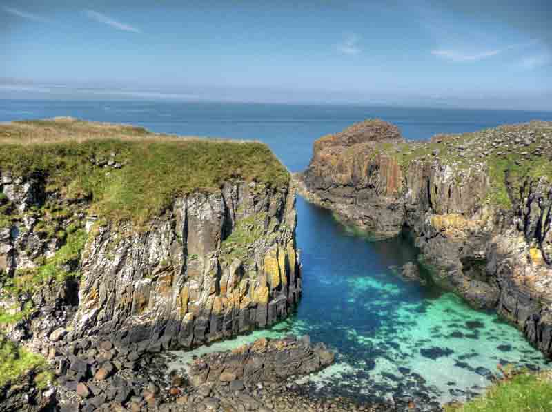
We were now fairly confident that we could continue the low level route all the way to the old hill fort of Dun Channa at the western tip of the island and so it proved. Fairly easy walking past a succession of colourful little inlets and bemused sheep...

We finally reached the end of the island and were just about to sit down for Bob`s third lunch of the day when we saw a figure at the top of the cliffs. "Bloody hell" we thought..."never thought we`d see anyone out here." The guy scrambled down and then traversed along towards the old hill fort of Dun Channa.
The cliffs are quite big here...you can see the unknown person traversing if you intersect the two red lines I have put on the pic..

Cheered by the prospect of meeting another weirdo like ourselves we wandered over to have a look at the old hill fort. It turned out the guy was no less than the Stewart Connor, the new National Trust manager for the Isle of Canna. He`d only been in the job a few weeks and was out on his first visit to the fort. Stewart and myself going up to the fort. This is the only feasible access....

We passed a half an hour or so and he told us about his plans for Canna. These apparently involve the installation of a large Ferris wheel at the jetty and the sacking of everyone on the island with the surname MacKinnon. We wish him well in his endeavours
Stewart was enthusiastic and proved quite knowledgeable about the fortifications and discovered old cup and ring marked rocks that hadn`t been recorded as of yet. We toiled up the cliff together to go our separate ways. Just when we thought the day couldn`t get any better a huge basking shark appeared below us circling around the bay below....

Having seen bucket loads of them the previous day we were just going to walk away but decided to video it for you lot out there
It was still circling round 20 minutes later when Bob and I left to head over to Sron Ruail to bag the trig pillar which resides there. It really was warm now so we took our boots off and rewarded ourselves with a half hour snooze. Cracking view of Dun Channa from up here. It`s the round outcrop on the left and would be surrounded by water when the tide is in.

Onwards again along the top of the amazing sea cliffs at Brè Sgorr before turning eastwards towards the Nunnery. Heading towards the Nunnery and looking back to Brè Sgorr...

Looking east with Rum behind...

The old nunnery is notoriously hard to access but Stewart had told us that there was a rope in place to get down the hardest part.

We got down no problem and had a wander round the remnants of the original beehive cell and other ruins. There was an amazing old water viaduct come well which was still in perfect condition after almost 1300 years or thereabouts. Well worth the effort of getting down there.
The Nunnery on Canna...

Back up the cliff we went which was much easier than going down. The access route is a slimy and very loose gully which looks like it is permanently subject to run off from the plateau above. While this would have provided a reliable source of water for the early Christian nuns it also means that the first 50 feet of descent are pretty nasty. After that initial bit it is a stroll. If anybody intends going here it would be advisable to go down one at a time...wait until the first person is down and clear of the bottom as the rope movement can dislodge loose rock.
Heading eastwards again we had a short look at the site of another hill fort before descending the wonderfully named Tota Tarra
Eventually we arrived at Tarbert Bay and the start of the land rover track back to the tents. The bay sported a fine wee beach and a miniature version of the Giant`s Causeway.
Looking back on Tarbert Bay...

We were feeling the pace now and the stony surface was doing our poor feet no favours.
Sair feet time

We were glad to reach the water tap at the farm I can tell you . We arrived back at the tents completely knackered after a 13 hour day. A quick meal and then down 20 feet below the tents to the beach where we lit a small fire below the high tide mark,opened a half bottle of Glenmorangie and were the happiest people on the planet that day

Route description from Camas Thairbearnais:
From Camas Thairbearnais head uphill and traverse around the top of the inlet that you can see and then drop down again to the terrace. Wander along here under the cliffs weaving your way in and out of the large rocks that have fallen down. Very easy grassy walking. At the first gully follow a sheep track up left crossing a little rock slab which looks to be permanently covered in mud and was quite slippy. Only one or two moves.
Drop back down to the terrace again and continue westwards. Eventually you will come to a section that is completely impassable . Double back and go up the eastern side of the last obvious gully you will have passed and after 100 feet or so you will see two obvious sheep tracks on the other side. Cross over and take a rising traverse until you come to a little bit of scrambling. Climb up the crag trending leftwards on big bucket steps and you are at the top of the cliff
6 comments:
Aye well done guy's was a pleasure meeting with you at such a remote location. Love the blog and the photos are superb a great advert for Scotland. Hope one day to meet you again on Canna. Dunno about the ferris wheel but Clan MacKinnon will still be well represented. Slainte
Another great day out with the bluesky boys! Superb pictures again. The great thing is that I know we'll be off to Canna in the not too distant, so I'll definitely chack this route out. No chance at all of weather and light like you had I'm sure.
Great footage of the basking shark: there seem to be a lot of them around this year.
all the best
Peter
I adore the reflection in the 'cooling off the feet' shot
there's something some magical about all your photos
Nice to meet you too Stewart and thanks for the archaeology lesson and tip about the rope.Hope you are settling in ok :)
Peter,I know you are a Jura addict but you will not be disappointed on Canna.You might want to check the route description for errors because we were suffering from sunstroke at the time :)
Stewart has some cheap accomodation on Canna if you are interested...good luck..!
Dianne,the only magical thing about the pics is that it is sunny and it is Scotland.!
Alex.
Stewarts right,your pictures really are a great advert for this rugged countryside of ours. About the seals being nosy,I've just been reading about some folk swimming with them in Loch Linnhe.Now there's an interesting idea.
Sounds (and looks) wonderful! I am going to take the wife there soon. We've never been to Eigg either so maybe make a week of it.
Post a Comment