Wednesday 27 November 2019

English Lake District. Glenridding. Ullswater Gallery.

                                             ALL PHOTOS CLICK FULL SCREEN
A gallery of autumn photos taken around the Glenridding and Ullswater Districts.
Tree cover in the Lake District and even the hills themselves have been 'beautified' since Victorian times, sculpted, planned, and moulded for  many generations ... which is why I and countless others like it so much.
You do not get 'natural' beauty like this accidentally, yet you see spectacular views like this one around every corner in the Lake District. This is Ullswater and Glenridding. The path network is also superb with brilliantly laid out foot paths at every level from valley bottom to mountain summit.
Local Glenridding Shop. I,m willing to bet the Lake district has more quality scenic paths than in all of West Coast Highland Scotland put together- an area 10 times its size. It's why I love coming down here so much. In any weather conditions. Always something new to see.
Leaving the climbing hut early on the Saturday I decided to do part of the Ullswater Way which provides a 21 mile hike around the popular and very beautiful steamer lake. It's not as busy as Windermere with a semi quiet road running along one bank of this large lake and the other side, seen here, just grass paths or farm tracks.
Even walking along the main road is picture postcard pretty in every direction- hence my 'golden bubble' tag. Local church in Glenridding here. The locals make this area as well. They always seem polite, friendly and energetic in the Lake District and put a great deal of time and effort into keeping it looking this good. Although the Lake District gets the reputation of being busy I've not really found that myself as we tend to go either in the off season (first week in November this time) or when its less than perfect weather. Passing through Kendal and along Windermere was the first time we have encountered bad traffic build up but I think that stretch is well known for that as it's the main access corridor for all the English cities like Liverpool, Manchester, Birmingham and London into the heart of the Lakes.
In the Scottish Highlands this kind of gloomy weather over the mountains, (cold, damp, and claggy grey), would be scunnering and dreich but here it was a joy to get up and explore, mainly due to the delightful path network and the small rugged crags that seem to grow in abundance around here, often covered with a cornucopia of every type of tree. Visual riches to a forest lover and tree aficionado like me, especially in late autumn with colours at their finest.
So I left this... looking up Ullswater to the mountains around Kirkstone Pass... The goblin haunted Misty Mountains ... grey and uninviting...Yuk!
and stepped into this instead....
The kaleidoscopic colours of Patterdale Hall and Estate. As good as a burst of sunshine on my soul. The sheer variety of different trees here is astonishing in its beauty and diversity.
The Meadow. Glenridding. Ullswater Way.
Glenridding Village Shops. Our stores for a weekend. A former mining village up until the 1960s producing quality lead for several centuries right up until the 1960s and one of the largest in the country. You can see spoil heaps in the second top photo above the farm. According to reports it might be possible to open the mine up again as a tourist attraction. I'm in two minds about that as Glenridding is pleasantly tranquil and quieter than other areas at present so hopefully that will not change its character too much.
Glenridding Pier where the steamers sail down Ullswater.. You can also hire kayaks and boats here or at nearby St Patrick's Bay.
And this is it here, viewed from a level balcony trail on the slopes of Place Fell, just slightly higher up than the Ullswater Way, offering a fantastic range of views over Ullswater.
Another view from the balcony trail looking towards Patterdale. This trail takes you out at Rooking. It's not that high up the hillside but outstanding scenery. World class views.
Another Japanese maple and a view of Patterdale.
An average landscape for this area- anywhere else- exceptional scenery.
Dead Badger. Not all golden here. Life and death goes on regardless  and Glenridding suffered badly a few years ago with devastating floods. Not much sign of that now though.
Enchanted hamlet in a magic kingdom.
House in the woods. Ullswater Way view.
The mouth of the Red Tarn Beck- one of the culprits that caused the flooding here when a months worth of rain fell in one day transforming quiet streams into raging torrents that washed away part of the main road and protective banks within hours. A common occurrence now down in England which has many more historic towns and villages situated next to streams and rivers.
The same Red Tarn Beck looking upstream. Glenridding has recovered well and if you did not know the recent history you would never suspect it had been flooded. Cockermouth and Kendal are other recent flooding victims, both towns with rivers running through the centre. Hopefully, they have had their share of bad luck now. The very thing that draws tourists into the Lake District in the first place- steep mountains, gurgling streams and plentiful water, dotted with pretty towns and villages- may just be it's Achilles heel. But I hope not.
Ullswater and Glenridding Pier from Place Fell.
Path passing St Patrick's Well and Bay. Even though the Ullswater Way follows the road in places it's not that busy with only a handful of cars usually, especially in the morning, and it does not spoil it as a walk in any way to my mind.
Not with scenery like this....
Plenty of places to escape into the wilds- The balcony trail here...
And low level highlights. The End....                            to be continued...


Tuesday 26 November 2019

English Lake District Weekend. Kendal.

                                                 ALL PHOTOS CLICK FULL SCREEN
A club trip to the English Lake District at the start of November and nicely timed to catch the best of the autumnal tree colours at their peak. As I've learned over the years anytime you see a bright burst of vivid red in the deciduous landscape in autumn it is usually a maple of some sort- in this case a Japanese maple.
Not too sure why we ended up in Kendal on the Friday afternoon as we were actually heading for Glenridding to a favourite hut but we either missed the turnoff, it had major roadworks on the Penrith to Ullswater road info somewhere,...or driver Alex just fancied a different route. Kendal Town Hall here, above. A nice old building.
A close up detail of the town hall entrance, erected in 1827 apparently before being used as a town hall so maybe this later date in stone refers to something else, like the elaborate archway, as it doesn't seem to match the conversion date either from district assembly rooms to town hall.
We parked up in a car-park in the town centre then had a wander round. I fancied seeing the castle on the hill but we picked the wrong one. Kendal Castle sits on a similar small hill on the opposite side of town and is a ruin, but still an obvious structure whereas this, Castle Howe on Bowling Fell, is just a heap of rubble topped with a monument to The Glorious Revolution when the Catholic King James II lost the throne and the land to his Daughter Mary and William of Orange. Turns out this is Kendal's first castle though and is very ancient, built around the 11th century, long before Kendal Castle. It is surrounded on one side by Beast Banks, now a modern road but maybe named after part of the original fortifications surrounding the castle.
It was a very murky wet afternoon and my companion's  heart was not in this walk at all. I on the other hand was determined, now we were here, to have a wander around and see the place fully so we split up after this point. He to visit the numerous charity shops along the main street for bargains- me to explore. We would meet back at the car in one hour. That suited us both.
Carnegie Library. Kendal. I've written about Andrew Carnegie before in a post about Dunfermline- a unique philanthropist who gave most of his immense fortune away in later life, founding education and learning institutions worldwide. The English speaking countries anyway. He believed that access to books and education could open up a doorway of opportunity for anyone willing to undergo that journey as he himself was born poor in Scotland, in a similar sized town to Kendal.
From there, after looking at a town map info board,  I made my way down to the river to do an obvious circular walk of this small Lake District town. Unlike other small towns within the Lakeland 'golden bubble' Ambleside, Cockermouth, Penrith, or Keswick say,  Kendal feels slightly more industrial as it has several large mills, seen here, now converted into apartments and small businesses. Bridge Mills business centre being listed nearby on a notice board. Originally wool products, carpet making, snuff tobacco and textiles in the various large buildings seen in town but it does have pretty areas as well and attractive buildings but more of a mishmash than the other 'Golden Bubble' towns seen down here.
In many ways, with these high mill buildings, it reminds me of Barrhead, Paisley and Neilson, mentioned in the last post, also major textile hubs with a legacy of manufacturing. In another coincidence  I've been in Kendal once before. I was around 14 at the time and came here on a Barrhead bus run with my parents. Being a typical teenager, embarrassed and awkward, I sat well away from them at the back of the bus, pretending to be on my own, and met up with a family from Hamilton, another bus pick up point, like ours, on the journey down. They had two children and I got on really well with them. I remember that. I also remember exploring Windermere with them and being completely entranced. No recollection of what Kendal was like though. That passed in a dream.
New apartments in Kendal which look like the architects have replicated the mill look here. A common trick with architecture in towns where they often mirror existing prominent structures.
One of several bridges over the River Kent (Kent Dale) from which the town derives its name. Like many other parts of England this sizable river is prone to flooding so it's a double edged sword- scenic beauty and useful past industrial development which allowed towns like Kendal to prosper versus a serious threat of flooding and damage to property.
A fish eater on the river faces the same predicament. Shags and cormorants do not have very waterproof feathers so have to dry them off frequently between dives- yet this may be an aid to fast underwater fishing as a lack of trapped air in the feathers means less buoyancy overall and less energy used to stay under.
One of the weir across the River Kent. A nice walk this, even on a wet day.
Further down the river I cut over another bridge and used a quiet lane/yard to get back up towards the main shopping street.
I puzzled over the nature of these sturdy, narrow back passageways called 'yards' until I found a town info board explaining them. Turns out these fortified back lanes, running arrow straight off the main street in their dozens originated as a defensive measure against raiding parties, both Scots and English, during the border conflicts, 14th to the 17th century, which would suggest Kendal is one of the older Lakeland towns. They are not yards in the more conventional sense as in a square or rectangular clearing- more narrow deep corridors between buildings to kettle in unwanted intruders, maybe setting them up for an ambush as you could fire straight down them at anyone caught inside. No doorways or alcoves to hide in here.
I then stumbled by luck on the Brewery Arts Centre which was a little green oasis off the main, very busy, shopping street. I was delighted to find this as I could easily have missed it.
A blend of autumn colours. Brewery Arts Centre.
And a stair leading up to a well placed sculpture....
This sculpture.
 A view over to the ruins of Kendal Castle from the Arts Centre.
Carved pumpkins in Kendal. The magnificent eight.
The main shopping street in Kendal at rush hour. The only drawback of our visit to Kendal was the volume of traffic between Kendal and Windermere which was heavy and relentless  5 mile per hour nose to tail movement. When people say the Lake District is too busy they probably mean this section from Kendal to Windermere as the traffic was fine everywhere else. Kendal is not as picture postcard pretty as other Lakeland towns but it does have a fascinating history. This level of rush hour traffic along the main shopping streets every week day however might put some tourists off but you can escape it easily enough down by the riverside or on the castle walks.
To be continued... and the best is yet to come.


Saturday 16 November 2019

Barrhead. Renfrewshire. The Town and Surroundings.

                                              ALL PHOTOS CLICK FULL SCREEN
This is the missing link between the two previous blog posts, completed on the same walk from South Nitshill, getting off bus number 57 then walking to Barrhead and then over the Fereneze Hills to Paisley.
Salterland Road, seen here above, a quiet, pleasant country lane leading from South Nitshill, Glasgow, into the nearby town of Barrhead in Renfrewshire. You can either take the main Darnley Road pavement walk (faster but busy with traffic), this slightly longer but greener corridor, or make you own way across the landscape, as described in a previous post a month ago. By the last two routes, all going well, you will end up here.
The Glasgow/Barrhead Boundary. A Railway Bridge. The same railway line and similar bridge that separates South Nitshill from Nitshill... and South Nitshill from Priesthill. For adults just an information sign and underpass but as a young teenager growing up, aged 10 to 16, these were important markers. A Portal. Going into Barrhead was the most inviting doorway, one we did often, either with friends or by myself. Going into Nitshill, under a similar bridge, not so bad either but higher up the scale of wary trepidation, looking out for trouble. Going across the railway line into Priesthill circa 1960s to 1980s ... always an exciting adventure. Even as an adult, working there every day.     An education.
A view of the Fereneze Hills/Brownside Braes. The path over to Paisley follows the line of houses,  right to left, then upwards diagonally at the end house, left to right. Before you reach that point however you have to go through Barrhead itself.
The minor country lane of Salterland Road takes you out onto the busier A736 Glasgow Road, which, after the railway bridge, leads you past a small industrial estate of garages, small business units, etc but with a good view ahead of Duncarnock's rocky summit and St John's Catholic church. This is it below. I like a nice Gothic spire sticking up in the landscape even though I'm not religious.
.At the same roundabout where this Catholic church stands I took a slight detour off route to head back up Darnley Road to visit Cowan Park, a Barrhead gem.
This was the closest public park to us living in South Nitshill, so we made regular trips to it from aged five to twenty five, when I moved away from the area. It was 30 minutes pleasant walk from the family doorstep to here and another five minutes to Barrhead's Shopping Centre so a very familiar walk and town to us back then.
Cowan Park has not changed much at all in the last 50 years. The bandstand is still there, the small playground of swings, monkey bars, roundabout and slide, always a childhood treat, has been replaced by a larger, more modern adventure play area for today's children but other than that it's untouched.
Quite a large park but half of it is seen in this photo with the distant boundary line of a dark hedge and spiked railing just visible. In twenty odd years we never walked down here when I lived in the area as there was not much to attract us in this sector but I did it on this occasion just out of curiousity. Nope, there's nothing much down there....my eyes did not deceive me... but I did meet a same aged local dog walker and had a good chat about where we went as children so that made it worthwhile.
A view from Cowan Park towards Auchenback, One of the largest schemes in Barrhead and looking much the same as I remember it. A few rows of tenements have been knocked down and replaced with newer, low level housing but other than that it's well maintained and in reasonably good condition for its age. (I know this as the number 3 McGill's bus from Neilston to Glasgow takes you round most of the streets within this very sizable estate on its weaving eventual route into the city. Local buses are amazing like that for seeing the best/deepest heart of every district on a journey :o) If you did it frequently it might prove irritating but as a twice off trip I found it both fascinating and enlightening to see the full extent of Auchenback in comfort, without legwork and expended energy. Built at roughly the same time as the original South Nitshill, what saved it from similar demolition and decay was cottage type housing with gardens, no large back courts for gang activity, tighter street layouts overall, and only a few rows of scattered tenements, some of which have been replaced. The photo view above only shows part of this large estate.
Barrhead High School from Cowan Park with another chunk of Auchenback behind it. Although not much has changed in Barrhead there are several notable additions- one of which is the new  Barrhead High School, seen here. East Renfrewshire scores high as one of the best UK places to raise a family apparently. Mind you, if they cover it all in houses, that may change.
I liked the architectural style of this building and the landscaped grounds surrounding it. Although not in a bad mood as I was enjoying this walk up to now I was surprised to find my mood lifting further, immediately and noticeably, crossing this area. So much so that while walking across this newly landscaped patch of ground (it was shut, a holiday, no pupils.) I had a sudden flash of insight between children growing up in this environment, (new school, good home, positive aspirational attitude), and children growing up in a rough area. (dilapidated houses, gangs, litter strewn waste ground where streets have been.) Even brought up with good parents, opportunities and academic ability this second environment must have some kind of corrosive effect on your mentality overall, seeing it day after day, without necessarily being aware of it happening. Even after you move away, carrying on years or even decades later in your psyche.
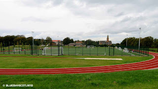
The new running track and sports ground. Vivid, intense. primary colours of red, green, and white. There was a real or half imagined fresh smell of newness off this track, which did not appear to have a single scuff mark on it. Visually stimulating to the senses. This was confirmed when I crossed out of this newly landscaped area back into ordinary Barrhead again and it was like the sun had vanished behind a cloud in my perceptions. I could not help remembering my own estate at the beginning, everything newly built, fresh, and sparkling as a first generation child let loose into this bright clean Eden, reflected in my own positive attitude growing up- then 30 years later when it was all dirty, damaged, and soiled- and a not so positive attitude... although again, not always consciously aware of this, by now ingrained negativity and slight cynicism to everything around me.
Coming out of the school grounds onto Aurs Road, beside Auchenback, scene of many a long circular walk up through the Barrhead Dams from my house, first done in a pram, as a baby, so I'm told, then walking with companions, then frequently, alone, as a fantastic freewheel long descent on a bike off the high moors after a Christmas present, turning 14 years old. A welcome passport to greater travelling ability and day long explorations further afield.
Barrhead and Dovecothall at the Roundabout. Left to Crossmill, the railway bridge, the Hurlet, then Pollok... right to South Nitshill, Darnley and Arden via Darnley Road. The white building used to be a well known pub, which closed, but is now an Indian restaurant.
Looking in the other direction towards Barrhead shops. A view unchanged since the 1960s. Just here where the photo was taken is the start of the Levern Water path/cycle track, a pleasant green ribbon that bypasses the urban centre of Barrhead by following this stream. At one time nearby Neilston and Barrhead had numerous separate cotton mills dotted along the length of the Levern Water, employing many thousands of workers within walking distance of their house. Barrhead also manufactured  porcelain bathroom ware, exporting its products to a world wide market. Nearly every family in our district and across the Central Belt sat on a Shanks white toilet and washed up in one of their sinks.
A link to that here.
http://www.portaltothepast.co.uk/article/3328/Shanks--Co-Ltd-1851-1969

For an out of the way small commuter town, as it is now, back then, like many towns and even villages UK wide, during the industrial British past, it had a wide range of important local industries... from carpet manufacturing, to large iron works to turning animals into useful leather goods.  At this same spot is this info board to the cotton mill that once stood near here, beside the Levern Water, until the early 1970s. Unbelievably, most of the workforce employed inside were young children, working long hours beside the adults. Worth a read. Luckily, I grew up in the 1960s- a golden age for personal freedom and not just in record sales.
It is also at this point that you can access the Levern Water path/cycle track and here it is. A green way to pass through Barrhead to the hills beyond. However, on this occasion I thought I'd visit the town centre.
The Flying Horse pub and a row of shops. Not changed in 50 years.
Barrhead Shopping Centre. Not a full modern walk in indoor arcade, just this frontage. Ironwork could do with a scrape and paint after 50 years or so but still OK. Shops all in use for a change. Barrhead Travel, a local company gone international, started out here and still have a shop in the town. We used to go on bus trips from Barrhead occasionally as a family to The Trossachs, The Lake District, and Fife. A local garage ran buses from here through Nitshill and Pollok, picking up locals in several appointed locations first. Not sure if that was an early Barrhead Travel operation? 1960s 1970s style.
All the change/ additions in Barrhead lie on the other side of the road from the original shopping centre. The new Asda supermarket. (I went in here to buy sandwiches and use the toilets) Opened 2014.
East Renfrewshire Council Offices. All these buildings on this side have been up about 5 to 7 years at a guess, but still look new.
Barrhead Health Centre.  The other addition on this side of the street is The Foundry. A drop in community/sports/ fitness hub but I never managed a photo of that as it was too busy with families in front of it, being a holiday.
Further up the street older buildings still dominate. Original Council Chambers and Burgh Court Hall. Built in the early 1900s but no longer used for that purpose. It's supposed to be a local museum, going by the sign outside, but I've never been lucky enough to find it open. May be defunct. Used now for Youth Development projects I think, going by the window displays.
But I've always liked this wee guy in the upper balcony. The Town Proclamation reader. The local pigeons love him as well.
St Andrew's Parish Church. Barrhead.
New houses in Crossmill. Barrhead. Replacing some of the earlier estate here.
And a final distant view of the University of Glasgow from the hills and fields between Nitshill and Barrhead. The tall stone spire above the old building.... the modern tall grey building to the left houses the University Gallery of Modern Art and Macintosh house/museum. The end.


.